Alexandria in Rapides Parish, Louisiana — The American South (West South Central)
Post-Civil War Alexandria
Side A
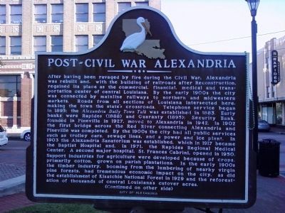
After having been ravaged by fire during the Civil War, Alexandria was rebuilt and, with the building of railroads after Reconstruction, regained its place as the commercial, financial, medical and transportation center of central Louisiana. By the early 1900s the city was connected by mainline railways to northern and midwestern markets. Roads from all sections of Louisiana intersected here, making the town the state's crossroads. Telephone services began in 1895; the Alexandria Daily Town Talk was established in 1883. Early banks were Rapides (1888) and Guaranty (1895); Security Bank, founded in Pineville in 1927, moved to Alexandria in 1942. In 1902, the first bridge across the Red River connecting Alexandria and Pineville was completed. By the 1900s the city had all public services such as trolley cars, sewage lines, and a power and ice plant. In 1903 the Alexandria Sanatorium was established, which in 1917 became the Baptist Hospital and, in 1971, the Rapides Regional Medical Center. A second major hospital, St. Francis Cabrini, opened in 1950. Support industries for agriculture were developed because of crops, primarily cotton, grown on parish plantations. In the early 1900s the timber industry, booming from the lumbering of nearby virgin pine forests, had tremendous economic impact on the city, as did the establishment of Kisatchie National Forest in 1929 and the reforestation of thousands of central Louisiana's cutover acres.
(Continued on other side)
Side B
(Continued from other side)
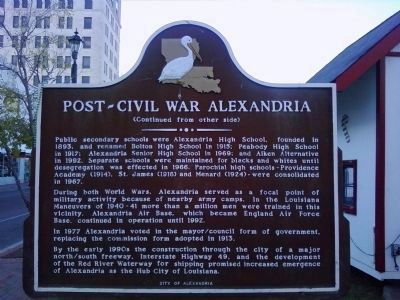
Public secondary schools were Alexandria High School, founded in 1893, and renamed Bolton High School in 1915; Peabody High School in 1917; Alexandria Senior High School in 1969; and Aiken Alternative i 1992. Separate schools were maintained for blacks and whites until desegregation was effected in 1966. Parochial high schools - Providence Academy (1914), St. James (1916) and Menard (1924) - were consolidated in 1967.
During both World Wars, Alexandria served as a focal point of military activity because of nearby army camps. In the Louisiana Maneuvers of 1940-41 more than a million men were trained in this vicinity. Alexandria Air Base, which became England Air Force Base, continue in operation until 1992.
In 1977 Alexandria voted in the mayor/council form of government, replacing the commission form adopted in 1913.
By the early 1990s the construction through the city of a major north/south freeway, Interstate Highway 49, and the development of the Red River Waterway for shipping promised increased emergence of Alexandria as the Hub City of Louisiana.
Erected by City of Alexandria.
Topics. This historical marker is listed in these topic lists: Education • Horticulture & Forestry • Industry & Commerce • Settlements & Settlers. A significant historical year for this entry is 1895.
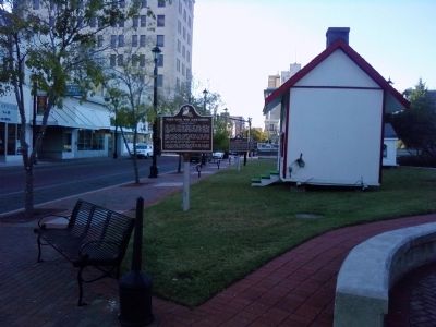
Location. 31° 18.661′ N, 92° 26.652′ W. Marker is in Alexandria, Louisiana, in Rapides Parish. Marker is on 3rd Street north of Johnston Street, on the left when traveling south. Marker is located in Alexander Fulton Park near the Commerce Building. Touch for map. Marker is in this post office area: Alexandria LA 71301, United States of America. Touch for directions.
Other nearby markers. At least 8 other markers are within walking distance of this marker. Alexander Fulton Park (a few steps from this marker); Alexandria (a few steps from this marker); Commercial Building (within shouting distance of this marker); Thomas Courtland Manning (within shouting distance of this marker); The Rotary Club of Alexandria, Louisiana (within shouting distance of this marker); City Of Alexandria Post Des Rapides (within shouting distance of this marker); Pinckney Benton Stewart Pinchback (within shouting distance of this marker); Rapides Parish Governors (about 300 feet away, measured in a direct line). Touch for a list and map of all markers in Alexandria.
Credits. This page was last revised on March 18, 2017. It was originally submitted on November 22, 2010, by Lee Hattabaugh of Capshaw, Alabama. This page has been viewed 1,205 times since then and 51 times this year. Photos: 1, 2, 3. submitted on November 22, 2010, by Lee Hattabaugh of Capshaw, Alabama. • Bill Pfingsten was the editor who published this page.


