North Charleston in Charleston County, South Carolina — The American South (South Atlantic)
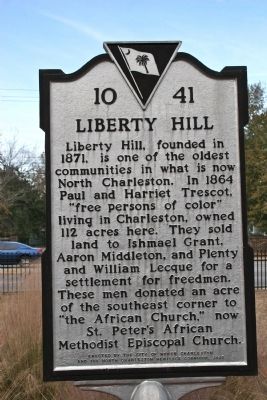
Liberty Hill
Erected 2005 by the City of North Charleston and the North Charleston Heritage Corridor. (Marker Number 10-41.)
Topics and series. This historical marker is listed in these topic lists: African Americans • Settlements & Settlers. In addition, it is included in the African Methodist Episcopal (AME) Church series list. A significant historical year for this entry is 1871.
Location. 32° 52.825′ N, 79° 59.787′ W. Marker is in North Charleston, South Carolina, in Charleston County. Marker is on Hassell Ave.. Touch for map. Marker is at or near this postal address: 4790 Hassell Ave, North Charleston SC 29405, United States of America. Touch for directions.
Other nearby markers. At least 8 other markers are within 2 miles of this marker, measured as the crow flies. Liberty Hill's Vietnam Fighting Men (a few steps from this marker); Charleston Station (approx. 0.4 miles away); Park Circle (approx. 0.6 miles away); Naval Hospital District (approx. 1.6 miles away); Charleston Naval Hospital Historic District (approx. 1.6 miles away); Marine Barracks (approx. 1.8 miles away); Navy Yard Officers' Quarters (approx. 1.9 miles away); Charleston Naval Yard Officers' Quarters Historic District (approx. 1.9 miles away). Touch for a list and map of all markers in North Charleston.
Credits. This page was last revised on June 16, 2016. It was originally submitted on December 16, 2010, by David Bullard of Seneca, South Carolina. This page has been viewed 2,291 times since then and 278 times this year. Photos: 1, 2. submitted on December 16, 2010, by David Bullard of Seneca, South Carolina. • Bill Pfingsten was the editor who published this page.

