Afton in Albemarle County, Virginia — The American South (Mid-Atlantic)
Albemarle County / Nelson County
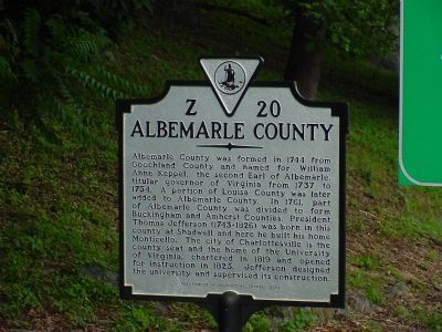
Albemarle County. Albemarle County was formed in 1744 from Goochland County and named for William Anne Keppel, the second Earl of Albemarle, titular governor of Virginia from 1737 to 1754. A portion of Louisa County was later added to Albemarle County. In 1761, part of Albemarle County was divided to form Buckingham and Amherst Counties. President Thomas Jefferson (1743–1826) was born in this county at Shadwell and here he built his home Monticello. The city of Charlottesville is the county seat and the home of the University of Virginia, chartered in 1819 and opened for instruction in 1825. Jefferson designed the university and supervised its construction.
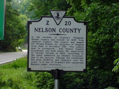
Nelson County. In the foothills of Virginia’s Piedmont,
Nelson County was formed in 1807 from Amherst County. The county was named for Thomas Nelson, Jr., governor of Virginia from June to November 1781. The county seat is Lovingston. The Nelson County courthouse was built under the supervision of George Varnum in 1809, according to the plans submitted by Sheldon Crostwait, one of the justices. Though the courthouse has been modified and enlarged over the years, it is one of Virginia’s best-preserved historic court structures.
Erected 2002 by Department of Historic Resources. (Marker Number Z-20.)
Topics and series.
Location. 38° 2.294′ N, 78° 50.001′ W. Marker is in Afton, Virginia, in Albemarle County. Marker is on Rockfish Gap Turnpike (U.S. 250) east of Afton Mountain Road (Virginia Route 6), on the right when traveling west. Touch for map. Marker is in this post office area: Afton VA 22920, United States of America. Touch for directions.
Other nearby markers. At least 8 other markers are within one mile of this marker, measured as the crow flies. Blue Ridge Tunnel (approx. 0.6 miles away); East Trailhead (approx. 0.6 miles away); Virginia's Nineteenth-Century Transportation Challenges (approx. 0.7 miles away); Claudius Crozet (approx. 0.8 miles away); The Blue Ridge Railroad (approx. 0.9 miles away); The Laborers (approx. one mile away); Flight of Richard C. duPont (approx. 1.1 miles away); Rockfish Gap Meeting (approx. 1.1 miles away). Touch for a list and map of all markers in Afton.
More about this marker. This marker replaced a marker with the same titles and number dating back to the late 1920s or early 1930s. The inscriptions on that previous marker read:
Nelson County. Area 473 square miles. Formed in 1807 from Amherst, and named for General Thomas Nelson, governor of Virginia, 1781. Oak Ridge, old home, is in this county.
Albemarle County. Area 751 square miles. Formed in 1744 from Goochland, and named for the Earl of Albemarle, titular governor of Virginia, 1737–1754. Thomas Jefferson was born in this county and lived in it.
Also see . . . The Nelson County Historical Society. There is a photo of the Nelson County courthouse on this page. (Submitted on December 7, 2007.)
Credits. This page was last revised on February 2, 2023. It was originally submitted on December 7, 2007, by J. J. Prats of Powell, Ohio. This page has been viewed 1,851 times since then and 49 times this year. Photos: 1, 2, 3, 4. submitted on December 7, 2007, by J. J. Prats of Powell, Ohio. 5. submitted on November 3, 2008, by J. J. Prats of Powell, Ohio.
