Waldo in Alachua County, Florida — The American South (South Atlantic)
Waldo
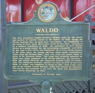
The first permanent English-speaking settlers came to the northeast portion of Alachua County in the 1820's. In 1837, during the Second Seminole War, an army post, Fort Harlee, was established on the Santa Fe River about three miles north of this spot. Abandoned as a military installation in 1838, the settlement at Fort Harlee served as a postal center for the surrounding community until 1858. In that year a post office was established at a town being founded at the point where the Florida Railroad (then under construction) would cross the Bellamy Road. This new town was named Waldo in honor of Dr. Benjamin Waldo. The name was probably selected by David Levy Yulee, president of the Florida Railroad. By February 1, 1859, the Florida Railroad was completed through Waldo to Gainesville. The Peninsular Railroad, planned as early as 1859 to run from Waldo to Tampa, was completed to Ocala in 1881. Both roads were part of the Florida Transit Railway. Waldo had become an important rail junction and continued to be until the shops and headquarters were moved beginning in 1929.
(Reverse text)
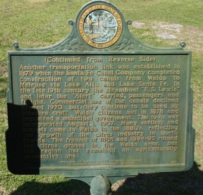
Another transportation link was established in 1879 when the Santa Fe Canal Company completed construction of two canals from Waldo to Melrose via Lake Alto and Lake Santa Fe. In the late 19th century the steamboat "F.S. Lewis" and later the "Alert" carried passengers and freight. Commercial use of the canals declined around 1920, but they continue to be used by pleasure craft. Waldo citizens met in 1876 and organized a municipal government. The town was incorporated August 1, 1907. Many settlers and tourists came to Waldo in the 1880's, reflecting the growth of the citrus industry in North Florida. The freezes of 1886 and 1894-95 ruined the citrus groves in the Waldo area, but the region has remained an agriculturally productive one.
Erected 1973 by Alachua County Historical Commission in Cooperation With Department of State. (Marker Number F-214.)
Topics. This historical marker is listed in this topic list: Notable Places. A significant historical month for this entry is February 1936.
Location. 29° 47.367′ N, 82° 10.102′ W. Marker is in Waldo, Florida, in Alachua County. Marker is on SW 5th Blvd. (State Road 24) near S.W. 2nd Way, on the right when traveling east. Touch for map. Marker is in this post office area: Waldo FL 32694, United States of America. Touch for directions.
Other nearby markers. At least 8 other markers are within 9 miles of this marker, measured as the crow flies. Dickison and His Men / Jefferson Davis' Baggage (here, next to this marker); For All Who Served (within shouting distance of this marker); Earleton, Florida (approx. 5.2 miles away); Turpentine Industry Community and Family (approx. 6.8 miles away); The Keystone Inn (approx. 8.3 miles away); I am a Veteran (approx. 8.3 miles away); Melrose United Methodist Church (approx. 9 miles away); Trinity Episcopal Church (approx. 9 miles away). Touch for a list and map of all markers in Waldo.
Also see . . . The Santa Fe Canal Company. Water was the primary means of transportation in the Waldo area during the 1870's and 80's. when the South was recovering from the hardships of reconstruction after the Civil War. There was limited access to railroads and a lack of good roads, leaving many areas using rivers and streams to transport their lumber, citrus, cotton, and other products to market. The new town of Melrose, located at the south end of Lake Santa Fe, was in need of better access to the Railroad The distance to Waldo and the closest railroad and depot was nine miles. Roads were so poor that four hours were required to get there by horseback or wagon. (Submitted on March 24, 2011, by Mike Stroud of Bluffton, South Carolina.)
Additional commentary.
1. National Register of Historic Places:
Waldo Historic District (added 2001 - District - #01000034)
• Roughly bounded by NW 1st Ave., Main St., SW 5th Blvd., and SW 4th St., Waldo
• Historic Significance: Event, Architecture/Engineering
• Architectural Style: Gothic Revival, Bungalow/Craftsman
• Area of Significance: Community Planning And Development, Architecture
• Period of Significance: 1850-1874, 1875-1899, 1900-1924, 1925-1949, 1950-1974
• Owner: Private , Local Gov't
• Historic Function: Commerce/Trade, Domestic, Education, Religion
• Historic Sub-function: Business, Religious Structure, School, Single Dwelling
• Current Function: Commerce/Trade, Domestic, Education, Religion
• Current Sub-function: Business, Religious Structure, School, Single Dwelling
— Submitted March 24, 2011.
Credits. This page was last revised on July 23, 2017. It was originally submitted on March 23, 2011, by Mike Stroud of Bluffton, South Carolina. This page has been viewed 1,055 times since then and 34 times this year. Photos: 1, 2, 3. submitted on March 23, 2011, by Mike Stroud of Bluffton, South Carolina.


