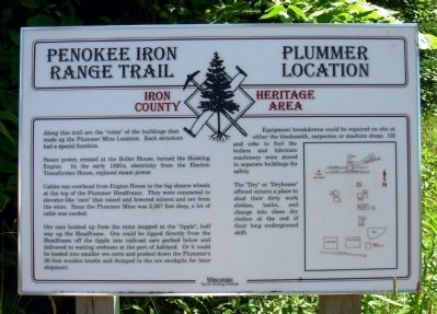
Penokee Iron Range Trail - Plummer Location
Iron County Heritage Area
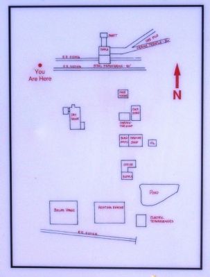
Steam power, created at the boiler House, turned the Hoisting Engine. In the early 1920’s, electricity from the Electric Transformer House, replaced steam power.
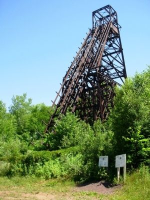
Cables ran overhead from Engine House to the big sheave wheels at the top of the Plummer Headframe. They were connected to elevator-like “cars” that raised and lowered miners and ore from the mine. Since the Plummer Mine was 2,367 feet deep, a lot of cable was needed.
Ore cars hoisted up from the mine stopped at the “tipple”, half way up the Headframe. Ore could be tipped directly from the Headframe off the tipple into railroad cars parked below and delivered to waiting oreboats at the port of Ashland. Or it could be loaded into smaller ore carts and pushed down the Plummer’s 36 foot wooden trestle and dumped in the ore stockpile for later shipment.
Equipment breakdowns could be repaired on site at either the blacksmith, carpenter, or machine shops. Oil and coke to fuel the boilers and lubricate machinery were stored in separate buildings for safety.
The “Dry” or “Dryhouse” offered miners a place to shed their dirty work clothes, bathe, and change into clean dry
clothes at the end of their long underground shift.Topics. This historical marker is listed in this topic list: Industry & Commerce.
Location. 46° 24.459′ N, 90° 17.582′ W. Marker is near Pence, Wisconsin, in Iron County. Marker can be reached from Plummer Road, ¼ mile south of Wisconsin Highway 77. Marker is located in Plummer Mine Headframe Interpretive Park. Touch for map. Marker is in this post office area: Montreal WI 54550, United States of America. Touch for directions.
Other nearby markers. At least 8 other markers are within 4 miles of this marker, measured as the crow flies. Penokee Iron Range Trail - Plummer Mine Geologic Layer Cake (here, next to this marker); Penokee Iron Range Trail - Plummer Mine (a few steps from this marker); Flambeau Trail – Flambeau Trail Crossing (approx. 2.2 miles away); Penokee Iron Range Trail – A Company Town (approx. 3 miles away); Penokee Iron Range Trail – Montreal Location (approx. 3 miles away); George W. Sullivan (approx. 3.4 miles away); The City of Montreal (approx. 3.4 miles away); Penokee Iron Range Trail – Gile Falls (approx. 3.6 miles away). Touch for a list and map of all markers in Pence.
Additional keywords. Mining
Credits. This page was last revised on June 16, 2016. It was originally submitted on August 2, 2011, by Paul Fehrenbach of Germantown, Wisconsin. This page has been viewed 1,240 times since then and 17 times this year. Photos: 1, 2, 3. submitted on August 2, 2011, by Paul Fehrenbach of Germantown, Wisconsin. • Bill Pfingsten was the editor who published this page.


