Near Avery in Shoshone County, Idaho — The American West (Mountains)
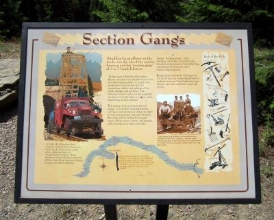
Section Gangs
Patrolling for problems on the track was the job of the section foreman and his “section gang” of 2 to 7 hardy laborers.
In the early 1900s the Milwaukee Road’s mainline was divided into 5.5 to 9.5 mile-long sections. A “gang” was assigned to each section for the inspection, safety and upkeep of the track, bridges and culverts. The foreman would walk over his assigned section every other day or once a week, depending on the weather.
The gang’s work was hard and ongoing. It included: clearing ditches, cutting weeds and grass along the right-of-way, keeping ties and rails secured, the track in line, fixing fences and signs, filling water stations and barrels, and clearing snow from switches.
Larger “floating gangs”, often working out of special work trains, handled major projects like ballasting, installation of new rails, and construction projects.
Keeping the electricity flowing was the job of special crews dispatched to problem areas in “troubleshooter” gas-electric rail-cars, and later, road-rail trucks.
(sidebar)
In 1949, the Milwaukee Road created a 10-truck fleet of road-railer repair rigs for their electric trolley crews, replacing three old “troubleshooter” trolleys. These handsome trucks with their hydraulic ladders helped keep the power flowing along the electrified mainline.
Topics. This historical marker is listed in this topic list: Railroads & Streetcars. A significant historical year for this entry is 1949.
Location. 47° 21.347′ N, 115° 38.582′ W. Marker is near Avery, Idaho, in Shoshone County. Marker can be reached from Cliff Creek Road (Federal Road 506) 1.8 miles north of Loop Creek Road (Federal Road 326). Located along the Route of the Hiawatha Trail. Touch for map. Marker is in this post office area: Avery ID 83802, United States of America. Touch for directions.
Other nearby markers. At least 8 other markers are within walking distance of this marker. No One’s “Fault” (approx. ¼ mile away); Bridging the Gaps (approx. 0.4 miles away); Tunneling Toward Tacoma (approx. 0.6 miles away); Temporary Trestles (approx. 0.6 miles away); Little in Name Only (approx. 0.6 miles away); The 1910 Fires (approx. ¾ mile away); The Big Blowup (approx. 0.8 miles away); The Olympian Hiawatha (approx. one mile away). Touch for a list and map of all markers in Avery.
More about this marker. On the upper right is a photo with the caption, "These proud, pipe puffing, section hands man a Sheffield motor car or “speeder”. With its single cylinder gasoline engine, the little cart could make 25 to 30 miles an hour carrying a small work crew and their tools." Photograph courtesy of Idaho State Historical Society
On the bottom is a map with the caption, "On the mainline segment from St. Regis, Montana to Avery, Idaho, the Milwaukee Road put section gangs at Drexel, Haugan, Melroe, Bryson, East Portal, roland, Adair, Falcon, Kyle and Stetson. Over the years, section divisions grew larger, while the number of sections dwindled."
Also see . . . Route of the Hiawatha Rail Trail. (Submitted on August 4, 2011, by Bernard Fisher of Richmond, Virginia.)
Credits. This page was last revised on June 16, 2016. It was originally submitted on August 4, 2011, by Bernard Fisher of Richmond, Virginia. This page has been viewed 613 times since then and 7 times this year. Photos: 1, 2. submitted on August 4, 2011, by Bernard Fisher of Richmond, Virginia.

