Johnson City in Washington County, Tennessee — The American South (East South Central)
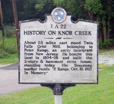
History on Knob Creek
Erected by Tennessee Historical Commission. (Marker Number 1A 22.)
Topics and series. This historical marker is listed in these topic lists: Industry & Commerce • Settlements & Settlers. In addition, it is included in the Tennessee Historical Commission series list. A significant historical year for this entry is 1817.
Location. 36° 21.532′ N, 82° 22.657′ W. Marker is in Johnson City, Tennessee, in Washington County. Marker is on East Oakland Avenue, 0.4 miles east of Bristol Highway (U.S. 11E), on the right when traveling east. Touch for map. Marker is at or near this postal address: 2833 East Oakland Avenue, Johnson City TN 37601, United States of America. Touch for directions.
Other nearby markers. At least 8 other markers are within 3 miles of this marker, measured as the crow flies. Isaac Hammer (approx. 0.8 miles away); Jesse Duncan (approx. one mile away); Knob Creek Church of the Brethren (approx. 2.2 miles away); Henry Massengill (approx. 2.4 miles away); Robert E. Young Cabin (approx. 2.4 miles away); Daniel Boone (approx. 2.4 miles away); Eliza Shaut White (approx. 2˝ miles away); William Bean's Cabin (approx. 2.8 miles away). Touch for a list and map of all markers in Johnson City.
Credits. This page was last revised on November 18, 2018. It was originally submitted on September 22, 2011, by PaulwC3 of Northern, Virginia. This page has been viewed 1,127 times since then and 65 times this year. Photos: 1, 2. submitted on September 22, 2011, by PaulwC3 of Northern, Virginia. 3. submitted on November 18, 2018, by Tom Bosse of Jefferson City, Tennessee.
Editor’s want-list for this marker. Photo of the Peter Range grave nearby • Can you help?


