Paoli in Orange County, Indiana — The American Midwest (Great Lakes)
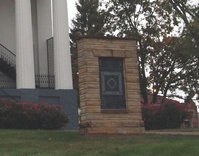
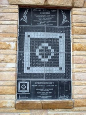
Indiana Initial Point Memorial
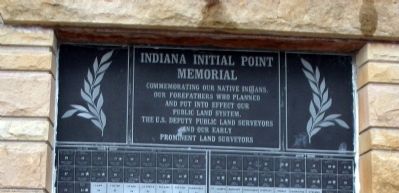
Inscription.
Commemorating our Native Indians, our forefathers who planned and put into effect our Public Land System, the U.S. Deputy Public land Surveyors and our early prominent land surveyors
( Center are the plotted Survey Plaques )
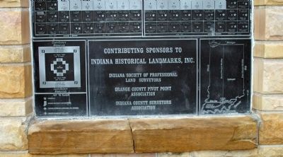
Contributing sponsors to Indiana Historical Landmarks, Inc.
Indiana Society of Professional Land Surveyors
Orange County Pivot Point Association
Indiana County Surveyors Association
( Two “Keys” to the survey )
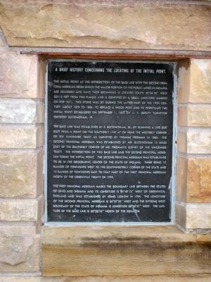
[[ Plaque ‘One’ - - Obverse Side ]]
A Brief History Concerning the Locating of the Initial Point.
The initial point at the intersection of the Base Line with the second Principal Meridian from which the major portion of the Public Lands in Indiana are described and have their beginning is located South 30°04'50" West 359.18 feet from this plaque and is identified by a small limestone marked on the top (S31). This stone was set during the latter part of the 19th Century (about 1879 to 1886) to replace a wood post and to perpetuate the initial point established on September 1, 1805 by U. S. Deputy Surveyor Ebenezer Buckingham, Jr.
The base line was established by E. Buckingham, Jr., by running a line due East from a point on the Southerly line at or near the Westerly corner of the Vincennes Tract as surveyed by Thomas Freeman in 1803. The Second Principal Meridian was established by Mr. Buckingham 12 miles East of the Southerly corner of Mr. Freeman’s survey of the Vincennes Tract. The intersection of this Base Line and the Second Principal Meridian forms the Initial Point. The Second Principal Meridian was established to be in the geographic center of the State of Indiana. There being 15 Ranges of Townships West to the Southwesterly corner of the State and 15 Ranges of Townships East to that part of the First Principal Meridian North of the Greenville Treaty of 1795.
The First Principal Meridian marks the boundary line between the States of Ohio and Indiana and its longitude is 84° 49'13" West of Greenwich, England and was established by Israel Ludlow in 1795. The longitude of the Second Principal Meridian is 86° 27'20" West and the extreme West Boundary of the State of Indiana is longitude 88° 05'31". The latitude of the Base Line is 38° 28'10" North of the Equator.
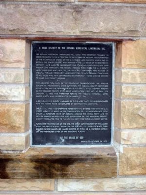
[[ Plaque ‘Two’ - - Obverse Side ]]
A Brief History of the Indiana Historical Landmarks Inc.
The Indiana Historical landmarks Inc., came into existence primarily in order to bring to the attention of the citizens of Indiana the importance of the rectangular system of the U. S. Public Land Surveys, which had its birth in the
States of Ohio and Indiana in the late years of the eighteenth Century. And also to memorialize our founding forefathers for their wisdom and foresight, the Indiana Indians, their tribes, the U. S. Deputy land Surveyors who laid out the Sections, Townships and Ranges in Indiana, the early prominent land surveyors of each Indiana County and to all those who have contributed so generously, funds and/or services to make this project possible.
Five members from each of the following organizations: the Indiana Society of professional Land Surveyors, the Indiana County Surveyors Association and an inspired group of citizens at Paoli, Indiana, known as the orange County Pivot Point Association, first met at Paoli on January 12, 1965 and thereafter formed the Indiana Historical Landmarks which was incorporated on March 17, 1965.
A boundary line survey was made of the 18 acre tract, the land purchased and an access road constructed by contributing assistance.
On July 22, 1968 a co-operative agreement was entered into with the U. S. Forest Service to assist in the continuation of the improvements, construct a miniature state of Indiana around the initial point and to provide proper maintenance and supervision of the memorial project. Shortly thereafter title to the site was conveyed to the U. S. Forest Service.
Funds for the purchase of the site,
the early construction of the access road, the erection and casting of the plaques, etc., were obtained from donors whose names, or names selected by them as memorial appear on the two outer bands of the memorial plaque.
By the Grace of God
Dedicated October 14, 1973
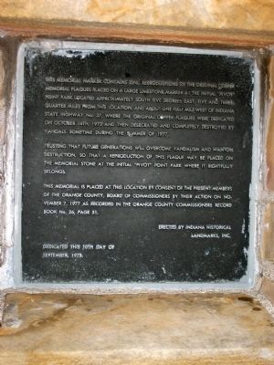
[[ Small Plaque - - Side of Memorial ]]
This memorial marker contains zinc reproductions of the original copper memorial plaques placed on a large limestone marker at the initial “Pivot” Point Park locate approximately South five degrees East, five and three quarter miles from this location, and about one half mile West of Indiana State highway No. 37, where the original copper plaques were dedicated on October 14th, 1973 and then desecrated and completely destroyed by vandals sometime during the Summer of 1977.
Trusting that future generations will overcome vandalism and wanton destruction, so that a reproduction of this plaque may be placed on the memorial stone at the initial “Pivot” point Park where it rightfully belongs.
This memorial is placed at this location by consent of the present members of the Orange County, Board of Commissioners by their Action on November 7, 1977 as Recorded in the Orange County Commissioners Record Book No. 26, Page 51.
Erected by Indiana Historical Landmarks, Inc.
Dedicated
this 10th Day of
September, 1978.
Topics. This historical marker and memorial is listed in this topic list: Landmarks. A significant historical month for this entry is January 1964.
Location. 38° 33.357′ N, 86° 28.11′ W. Marker is in Paoli, Indiana, in Orange County. Marker is at the intersection of Court Street (South Side) and South Gospel Street, on the left when traveling east on Court Street (South Side). Located on the South lawn of the Orange County Courthouse in Paoli, Indiana. Touch for map. Marker is at or near this postal address: 1 East Court Street, Paoli IN 47454, United States of America. Touch for directions.
Other nearby markers. At least 8 other markers are within 8 miles of this marker, measured as the crow flies. Orange County Civil War Memorial (a few steps from this marker); Orange County Revolutionary War Honor Roll / (a few steps from this marker); Orange County Honor Roll (within shouting distance of this marker); Orange County Courthouse (within shouting distance of this marker); Phoenix on the Square (within shouting distance of this marker); Paoli Historic District (about 300 feet away, measured in a direct line); Pivot Point (approx. 6.1 miles away); Orleans Congress Square (approx. 7.4 miles away). Touch for a list and map of all markers in Paoli.
Also see . . . Principal Meridian Project::. Additional photos, maps, and much more on the "Principal Meridian
Project". (Check out all its "links".) (Submitted on September 28, 2011, by Al Wolf of Veedersburg, Indiana.)
Credits. This page was last revised on June 16, 2016. It was originally submitted on September 28, 2011, by Al Wolf of Veedersburg, Indiana. This page has been viewed 1,310 times since then and 70 times this year. Photos: 1, 2, 3, 4, 5, 6, 7, 8, 9, 10, 11, 12, 13. submitted on September 28, 2011, by Al Wolf of Veedersburg, Indiana. • Bill Pfingsten was the editor who published this page.
