Train Trestle

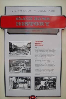
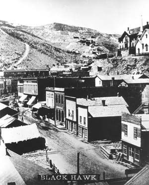
Looking west up Gregory Street with Masonic Building and Rohling Inn on the left. Copyright, Colorado Historical Society, Original Photographs, Scan #20004630.
Gregory Street on the left with train trestle beyond. Denver Public Library, Western History Collection X-2008
Pedestrians walking below trestle. Gilpin Historic Society.
Women on the train trestle. Gilpin Historic Society.
Gilpin County, Colorado
Black Hawk History
Gregory Street Crossing
The Colorado Southern Narrow Gauge Railroad (originally the Colorado Central Railroad) was vital to Black Hawk. During the late 1800’s aside from rugged wagon roads, it was one of the only means of transportation to Black Hawk to cross high above Gregory Street without disrupting pedestrian and wagon traffic below.
The train trestle was one of the most distinguishable structures in all of Black Hawk. Although passenger transport by train started to decline in the early 1900’s with the invention of the automobile, the trestle remained standing until 1970’s, when it was demolished for lumber.
During the 2007-’08 renovation of the Rohling Inn and expansion of the Fitzgeralds Casino, remnants of the trestle footings and support columns were uncovered, including the display piece below.
Topics. This historical marker is listed in this topic list: Railroads & Streetcars.
Location. 39° 48.083′ N, 105° 29.693′ W. Marker is in Black Hawk, Colorado, in Gilpin County. Marker is at the intersection of Gregory Street and Selack Street on Gregory Street. Touch for map. Marker is at or near this postal address: 200 Gregory Street, Black Hawk CO 80422, United States of America. Touch for directions.
Other nearby markers. At least 8 other markers are within walking distance
Also see . . . Colorado Central Railroad - Wikipedia. (Submitted on January 22, 2012, by Barry Swackhamer of Brentwood, California.)
Credits. This page was last revised on June 16, 2016. It was originally submitted on January 22, 2012, by Barry Swackhamer of Brentwood, California. This page has been viewed 877 times since then and 19 times this year. Photos: 1, 2. submitted on January 22, 2012, by Barry Swackhamer of Brentwood, California. • Bill Pfingsten was the editor who published this page.
