Rockport in Aransas County, Texas — The American South (West South Central)
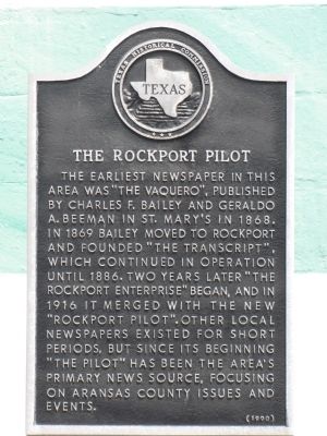
The Rockport Pilot
Erected 1990 by Texas Historical Commission. (Marker Number 4327.)
Topics. This historical marker is listed in these topic lists: Communications • Industry & Commerce. A significant historical year for this entry is 1868.
Location. 28° 1.346′ N, 97° 3.086′ W. Marker is in Rockport, Texas, in Aransas County. Marker is at the intersection of Wharf Street and South Magnolia Street, on the left when traveling west on Wharf Street. Touch for map. Marker is at or near this postal address: 1002 Wharf St, Rockport TX 78382, United States of America. Touch for directions.
Other nearby markers. At least 8 other markers are within walking distance of this marker. Site of Aransas Hotel (about 300 feet away, measured in a direct line); Rockport’s Grand Hotels (about 300 feet away); Rockport’s Wharves and Pavilions (about 400 feet away); The San Antonio and Aransas Pass Railroad in Rockport (about 400 feet away); The Packeries of Rockport (about 500 feet away); Sorenson-Stair Building (about 500 feet away); First Methodist Church of Rockport (about 700 feet away); Richard Henry Wood House (approx. 0.2 miles away). Touch for a list and map of all markers in Rockport.
Also see . . . The Rockport Pilot. Aransas County's community newspaper since 1869. (Submitted on March 19, 2012, by Bernard Fisher of Richmond, Virginia.)
Credits. This page was last revised on June 16, 2016. It was originally submitted on March 16, 2012. This page has been viewed 876 times since then and 41 times this year. Photos: 1, 2. submitted on March 16, 2012. • Bernard Fisher was the editor who published this page.

