South Berkeley in Alameda County, California — The American West (Pacific Coastal)
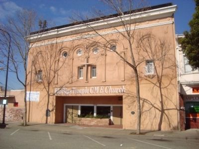
Lorin Theater
(Philips Temple C. M. E. Church)
— City of Berkeley Landmark, designated in 1982 —
James W. Plachek, Architect, 1921
The popularity of early movies created a demand for new spaces to accommodate eager audiences. South Berkeley’s first neighborhood theater with 144 stools for seats was established across Adeline Street in a storefront. In 1910 this building was constructed with 400 seats. It was soon enlarged to 800 seats. The owners advertised that “every foot of film’ that was shown has passed their own “personal inspection.”
In 1921 James Plachek redesigned the theater to provide 1,500 seats, an organ to accompany silent films, an Italian Renaissance-style facade and a large marquee. In 1954 the building began a second life as the home of the Phillips Temple C.M.E. Church. The congregation raised the substantial sum necessary to renovate the building in 1999 for earthquake safety and to restore much of the facade.
Erected 2000 by Berkeley Historical Plaque Project.
Topics and series. This historical marker is listed in these topic lists: Arts, Letters, Music • Churches & Religion • Notable Buildings. In addition, it is included in the Christian Methodist Episcopal (CME) Church series list. A significant historical year for this entry is 1910.
Location. 37° 50.88′ N, 122° 16.311′ W. Marker is in Berkeley, California, in Alameda County. It is in South Berkeley. Marker is on Adeline Street south of Alcatraz Avenue, on the right when traveling south. Touch for map. Marker is at or near this postal address: 3332 Adeline Street, Berkeley CA 94703, United States of America. Touch for directions.
Other nearby markers. At least 8 other markers are within walking distance of this marker. South Berkeley Bank (about 300 feet away, measured in a direct line); Historic "Lorin District" (about 400 feet away); Site of Reid's Records (approx. 0.4 miles away); Exxon Super Service Station (approx. 0.6 miles away); William Byron Rumford (February 2, 1908 - June 12, 1986) (approx. 0.6 miles away); Burl Toler, Sr. (approx. 0.6 miles away); Rumford's Pharmacy (approx. 0.6 miles away); Santa Fe Railroad Tracks (approx. 0.6 miles away). Touch for a list and map of all markers in Berkeley.
Credits. This page was last revised on April 23, 2023. It was originally submitted on March 23, 2012, by Barry Swackhamer of Brentwood, California. This page has been viewed 695 times since then and 21 times this year. Photos: 1, 2. submitted on March 23, 2012, by Barry Swackhamer of Brentwood, California. 3. submitted on April 23, 2023, by Ed Aust of Oakland, California. • Syd Whittle was the editor who published this page.


