Rochester Area
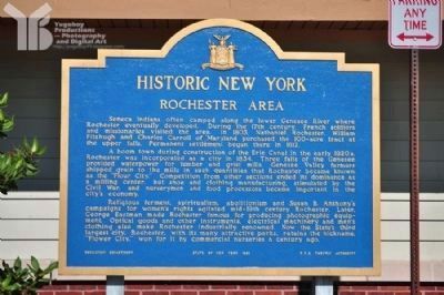
Historic New York
A boom town during the construction of the Erie Canal in the early 1820s, Rochester was incorporated as a city in 1834. Three falls of the Genesee provided waterpower for lumber and grist mills. Genesee Valley farmers shipped grain to the mills in such quantities that Rochester became known as the "Flour City." Competition from other sections ended its dominance as a milling center, but shoe and clothing manufacturing, stimulated by the Civil War, and nurserymen and food processors became important in the city's economy.
Religious ferment, spiritualism, abolitionism and Susan B. Anthony's campaigns for women's rights agitated mid-19th century Rochester. Later, George Eastman made Rochester famous for producing photographic equipment. Optical goods and other instruments, electrical machinery and men's clothing also make Rochester industrially renowned. Now the state's third largest city, Rochester, with its many attractive parks, retains the nickname, "Flower City," won for it by commercial nurseries
a century ago.Erected 1963 by Education Department, State of New York & the NYS Thruway Authority.
Topics and series. This historical marker is listed in this topic list: Settlements & Settlers. In addition, it is included in the Erie Canal series list. A significant historical year for this entry is 1803.
Location. 42° 59.929′ N, 77° 24.78′ W. Marker is in Victor, New York, in Ontario County. Marker is on NYS Thruway - Seneca Rest Area. Every NYS Thruway rest area has one of these. It is generally not visible from the Thruway, but if you pull off and park, you can read the one at the rest area you've stopped at. Touch for map. Marker is in this post office area: Victor NY 14564, United States of America. Touch for directions.
Other nearby markers. At least 8 other markers are within 3 miles of this marker, measured as the crow flies. Victor Centennial, 1913 (approx. one mile away); Mead Square (approx. 1.1 miles away); DeNonville's Army Ambushed (approx. 1.1 miles away); Athasata (Kryn) (approx. 1.2 miles away); Site of Home and Laboratory of Fred M. Locke (approx. 1˝ miles away); Park Place (approx. 1.7 miles away); Valentown Site (approx. 2.2 miles away); Binational Heritage Peace Garden Trail (approx. 2.2 miles away). Touch for a list and map of all markers in Victor.
Credits. This page was last revised on June 16, 2016. It was originally submitted on July 4, 2012, by Yugoboy of Rochester, New York. This page has been viewed 508 times since then and 23 times this year. Photos: 1, 2, 3. submitted on July 4, 2012, by Yugoboy of Rochester, New York. • Bill Pfingsten was the editor who published this page.


