El Dorado Springs in Cedar County, Missouri — The American Midwest (Upper Plains)
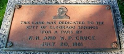
City Park Dedication
City of Eldorado Springs
for a park by
N. H. and W. P. Cruce
July 20, 1881
Topics. This historical marker is listed in these topic lists: Charity & Public Work • Settlements & Settlers. A significant historical date for this entry is July 20, 1881.
Location. 37° 52.576′ N, 94° 1.322′ W. Marker is in El Dorado Springs, Missouri, in Cedar County. Marker is in City Park, about 150 feet NW of the intersection of Main Street (Missouri Route 82) and Gay Street. Touch for map. Marker is in this post office area: El Dorado Springs MO 64744, United States of America. Touch for directions.
Other nearby markers. At least 8 other markers are within walking distance of this marker. El Dorado Spring (a few steps from this marker); Roy Bandy and Eddy Wilson (a few steps from this marker); Grindstone Wash Basin (within shouting distance of this marker); Nathaniel H. and Waldo P. Cruce (within shouting distance of this marker); Prairie (within shouting distance of this marker); Former School Districts in El Dorado Springs R-2 (approx. 0.6 miles away); Veterans Memorial (approx. 0.6 miles away); Missouri Bicentennial Wagon (approx. 0.7 miles away). Touch for a list and map of all markers in El Dorado Springs.
Also see . . . City of El Dorado Springs Town History. (Submitted on July 10, 2012, by William Fischer, Jr. of Scranton, Pennsylvania.)
Credits. This page was last revised on April 27, 2022. It was originally submitted on July 10, 2012, by William Fischer, Jr. of Scranton, Pennsylvania. This page has been viewed 493 times since then and 12 times this year. Photos: 1, 2. submitted on July 10, 2012, by William Fischer, Jr. of Scranton, Pennsylvania.

