Weber in Weber County, Utah — The American Mountains (Southwest)
Martin Henderson Harris
Sept. 29, 1820 - Feb. 14, 1889
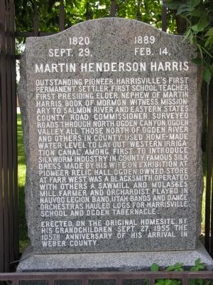
Photographed by Brent J. Belnap, July 2007
1. Martin Henderson Harris Marker
Erected on the original home site by his grandchildren Sept. 27, 1955 the 105th anniversary of his arrival in Weber County.
Erected 1955 by Grand Children of Martin H. Harris.
Topics. This historical marker is listed in these topic lists: Arts, Letters, Music • Industry & Commerce • Religion & Religious Structures • Settlements & Settlers. A significant historical date for this entry is September 27, 1955.
Location. 41° 17.003′ N,
this page online

Regionally, this marker is in the Wasatch Front and in Greater Salt Lake. It is also in the American Mountain West and on the Colorado Plateau. Globally, it is in North America, the Rocky Mountains, the Western Hemisphere, the Western World, and the Anglosphere. Historically, it finds itself in what was once New Spain and also Mexico’s Alta California.
Other nearby markers. At least 8 other markers are within 3 miles of this marker, measured as the crow flies: Chief Terikee (approx. 0.4 miles away); Levi & Josephine Taylor House (approx. half a mile away); Defense Depot Ogden (approx. 1.4 miles away); Marriott-Slaterville City (approx. 1.7 miles away); Bingham's Fort (approx. 1.7 miles away); Oldest Neighborhood / Bingham Fort / History in Plain Sight (approx. 1.9 miles away); Settlement of Lynne (approx. 1.9 miles away); Historic Pioneer Road (approx. 2.1 miles away).
Also see . . . Biographical materials on the life of Martin Henderson Harris. (Submitted on July 26, 2012, by Brent J. Belnap of New York, New York.)
Additional keywords. Mormonism, Church of Jesus Christ of Latter-day Saints
Credits. This page was last revised on January 9, 2020. It was originally submitted on July 26, 2012, by Brent J. Belnap of New York, New York. This page has been viewed 822 times since then and 13 times this year. Photo 1. submitted on May 11, 2012, by Brent J. Belnap of New York, New York. • Kevin W. was the editor who published this page.
