Takoma Park in Montgomery County, Maryland — The American Northeast (Mid-Atlantic)
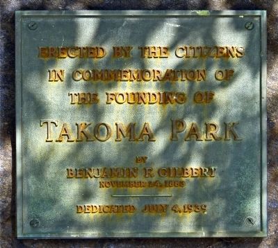
Founding of Takoma Park
Topics. This historical marker is listed in this topic list: Settlements & Settlers. A significant historical date for this entry is July 4, 1562.
Location. 38° 58.713′ N, 77° 1.102′ W. Marker is in Takoma Park, Maryland, in Montgomery County. Marker is on Piney Branch Road near Eastern Avenue & Takoma Avenue. The marker is at the east end of Upper Portal Park in Takoma Park Maryland at the DC line. Touch for map. Marker is in this post office area: Takoma Park MD 20912, United States of America. Touch for directions.
Other nearby markers. At least 8 other markers are within walking distance of this marker. The Thomas / Siegler House and Garden (approx. 0.2 miles away); Walt Penney Field (approx. 0.2 miles away); Belle Ziegler Park (approx. 0.3 miles away); Union Chapel (approx. 0.3 miles away); Takoma Station Tavern (approx. 0.3 miles away in District of Columbia); Original Federal Boundary Stone, District of Columbia, Northeast 2 (approx. 0.3 miles away); The Metropolitan Branch & Takoma Park (approx. 0.3 miles away); DC's Pollinator Network (approx. 0.3 miles away in District of Columbia). Touch for a list and map of all markers in Takoma Park.
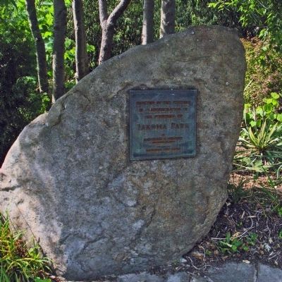
More about this marker. The marker is a plaque on a schist boulder pulled from nearby Sligo Creek.
Regarding Founding of Takoma Park. The town of Takoma Park is a Tree City, Azalea City and a Nuclear Free Zone.
Credits. This page was last revised on July 25, 2018. It was originally submitted on August 13, 2012, by Allen C. Browne of Silver Spring, Maryland. This page has been viewed 469 times since then and 6 times this year. Photos: 1, 2. submitted on August 13, 2012, by Allen C. Browne of Silver Spring, Maryland. • Bill Pfingsten was the editor who published this page.

