Jolon in Monterey County, California — The American West (Pacific Coastal)
De Anza Expedition 1775 - 1776
(Mission San Antonio de Padua)
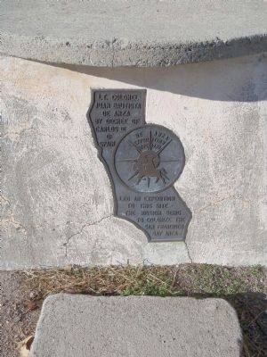
Lt. Colonel Juan Bautista de Anza by decree of Carlos III of Spain led an expedition to this site – The mission being to colonize the San Francisco Bay Area.
In the center of the marker is a circular motif, designed by Doris Birkland Beezley, of a rider superimposed upon a sun-like set of compass points, with the "De Anza Expedition 1775 1776" written above the rider.
Topics and series. This historical marker is listed in these topic lists: Exploration • Settlements & Settlers. In addition, it is included in the Juan Bautista de Anza National Historic Trail series list. A significant historical year for this entry is 1775.
Location. 36° 0.901′ N, 121° 14.949′ W. Marker is in Jolon, California, in Monterey County. Marker can be reached from Mission Road, 6.2 miles Jolon Road (County Route G14). Mission San Antonio de Padua and the De Anza marker are at the end of Mission Road on the Fort Hunter Liggett military reservation. Touch for map. Marker is in this post office area: Jolon CA 93928, United States of America. Touch for directions.
Other nearby markers. At least 8 other markers are within 14 miles of this marker, measured as the crow flies. First Marriage in California (about 300 feet away, measured in a direct line); The Hacienda (approx. half a mile away); Dutton Hotel (approx. 5 miles away); Jose Mario Gil Adobe (approx. 5.1 miles away); Jolon (approx. 5.2 miles away); Lockwood (approx. 10.8 miles away); Manchester (approx. 12.2 miles away); Mission San Antonio de Padua (approx. 13.8 miles away). Touch for a list and map of all markers in Jolon.
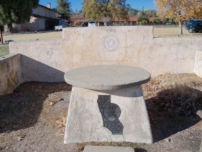
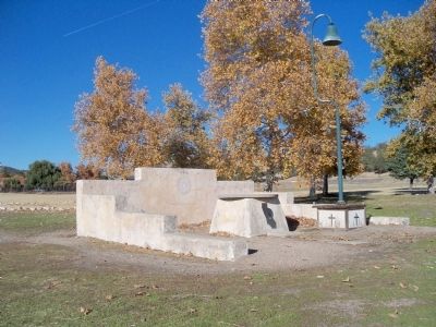
More about this marker. The marker is inside of a low, concrete walled, surround. With the mission doors at your back, the marker is about 200 feet to the southeast.
Also see . . .
1. Juan Bautista de Anza Blazed the Anza Trail. Juan Bautista de Anza was the first European to establish an overland route from Mexico, through the Sonoran Desert, to the Pacific coast of California. New World Spanish explorers had been seeking such a route through the Desert Southwest for more than two centuries. (Submitted on November 26, 2012, by James King of San Miguel, California.)
2. Juan Bautista de Anza National Historic Trail Guide. This is the National Park Service guide to the trail. (Submitted on November 26, 2012, by James King of San Miguel, California.)
3. The Anza Expedition (National Park Service Film). This film was released in 2012 and is a production of the
National Park Service and Environmental Exchange. (Submitted on November 26, 2012, by James King of San Miguel, California.)
4. California Highways Trails and Roads: De Anza Trail. The Juan De Anza Trail is a National Park Service Historic Trail that illustrates the interweaving of the three elements of the Spanish plan for colonization of its norther frontiers: the presidio, the mission, and the pueblo. It commemorates the route followed by Anza in 1775-76 when he led a contingent of 30 soldiers and their families to found a presidio and mission on the San Francisco Bay. Along the trail route, the visitor can experience the varied landscapes similar to those the expedition saw; learn the stories of the expedition, its members, and descendants; better understand the American Indian role in the expedition and the diversity of their cultures; and appreciate the extent of the effects of Spanish colonial settlement of Arizona and California. The Auto Route approximates the Historic Trail, and covers over 1200 miles between Nogales Mexico and San Francisco California. (Submitted on November 26, 2012, by James King of San Miguel, California.)

Photographed By James King, November 24, 2012
4. Informational Sign Along Mission Road
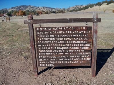
On March 6, 1776 Lt. Col Juan Bautista de Anza arrived at this mission on his famous overland expedition from Sonora, Mexico to Monterey and San Francisco.
He was accompanied by 240 colonists and the diarist, Padre Pedro Font, who wrote "The Indians of this mission are totally distinct from those I have hitherto seen." He recorded the place as "Mission San Antonio in the Valley of the Oaks."
Credits. This page was last revised on September 19, 2020. It was originally submitted on November 26, 2012, by James King of San Miguel, California. This page has been viewed 855 times since then and 48 times this year. Photos: 1, 2, 3, 4. submitted on November 26, 2012, by James King of San Miguel, California. • Syd Whittle was the editor who published this page.


