Collierville in Shelby County, Tennessee — The American South (East South Central)
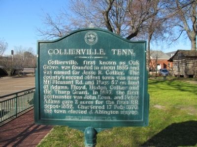
Collierville, Tenn.
Erected 1981 by Citizens of Collierville and the Shelby County Historical Commission.
Topics. This historical marker is listed in this topic list: Settlements & Settlers. A significant historical date for this entry is February 17, 1870.
Location. 35° 2.537′ N, 89° 39.906′ W. Marker is in Collierville, Tennessee, in Shelby County. Marker is on North Rowlett Street west of North Main Street, on the right when traveling west. Touch for map. Marker is at or near this postal address: 64 N Rowlett St, Collierville TN 38017, United States of America. Touch for directions.
Other nearby markers. At least 8 other markers are within walking distance of this marker. Battle of Collierville (within shouting distance of this marker); Collierville Civil War Battles Memorial (within shouting distance of this marker); The Wigfall Grays (within shouting distance of this marker); History Of The Collierville Town Square (within shouting distance of this marker); Collierville United Methodist Church (within shouting distance of this marker); a different marker also named The Battle of Collierville (within shouting distance of this marker); Memphis & Charleston Railroad (within shouting distance of this marker); The Original Depot (within shouting distance of this marker). Touch for a list and map of all markers in Collierville.
Credits. This page was last revised on October 20, 2023. It was originally submitted on February 8, 2013, by Judith Barber of Marietta, Georgia. This page has been viewed 621 times since then and 42 times this year. Photos: 1. submitted on February 8, 2013, by Judith Barber of Marietta, Georgia. 2. submitted on October 20, 2023, by Dianne Bowders of Fayette Co., TN. 3, 4. submitted on February 8, 2013, by Judith Barber of Marietta, Georgia. • Bernard Fisher was the editor who published this page.


