Annapolis in Anne Arundel County, Maryland — The American Northeast (Mid-Atlantic)
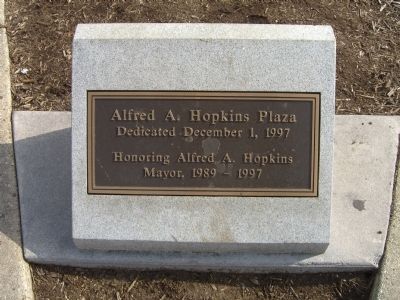
Alfred A. Hopkins Plaza
Mayor, 1989 - 1997
Erected 1997.
Topics. This historical marker is listed in this topic list: Government & Politics. A significant historical year for this entry is 1989.
Location. 38° 58.654′ N, 76° 29.256′ W. Marker is in Annapolis, Maryland, in Anne Arundel County. Marker is at the intersection of Market Space and Main Street, on the left when traveling west on Market Space. Touch for map. Marker is at or near this postal address: 36 Market Space, Annapolis MD 21401, United States of America. Touch for directions.
Other nearby markers. At least 8 other markers are within walking distance of this marker. Roger W. Moyer (here, next to this marker); Memorial Circle & Market House Plaza (a few steps from this marker); A Story of Preservation (a few steps from this marker); Coastal Evolution (a few steps from this marker); History Stone (within shouting distance of this marker); Kunte Kinte-Alex Haley Memorial (within shouting distance of this marker); The Market House (within shouting distance of this marker); a different marker also named Kunte Kinte-Alex Haley Memorial (within shouting distance of this marker). Touch for a list and map of all markers in Annapolis.
More about this marker. Prior to 1997, this area was known as the Market House Plaza (see nearby marker).
Also see . . . Alfred Hopkins; Popular Annapolis Mayor Stuck to Blue-Collar Roots. An article by Yvonne Shinhoster Lamb, published in The Washington Post on Friday, June 23, 2006, following Mr. Hopkins death the previous day. (Submitted on March 19, 2008, by Kevin W. of Stafford, Virginia.)
Credits. This page was last revised on February 13, 2022. It was originally submitted on March 19, 2008, by Kevin W. of Stafford, Virginia. This page has been viewed 1,196 times since then and 20 times this year. Photos: 1, 2. submitted on March 19, 2008, by Kevin W. of Stafford, Virginia.

