Dames Quarter in Somerset County, Maryland — The American Northeast (Mid-Atlantic)
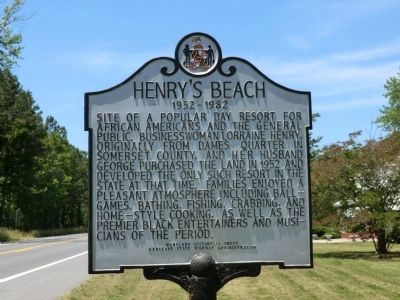
Henry's Beach
1952-1982
Erected by Maryland Historical Trust, Maryland State Highway Administration.
Topics. This historical marker is listed in these topic lists: African Americans • Entertainment. A significant historical year for this entry is 1952.
Location. 38° 11.317′ N, 75° 53.917′ W. Marker is in Dames Quarter, Maryland, in Somerset County. Marker is at the intersection of Deal Island Road and Hudson White Road on Deal Island Road. Touch for map. Marker is in this post office area: Deal Island MD 21821, United States of America. Touch for directions.
Other nearby markers. At least 8 other markers are within 9 miles of this marker, measured as the crow flies. Joshua Thomas (approx. 3.6 miles away); Roaring Point Park (approx. 5˝ miles away); a different marker also named Roaring Point Park (approx. 5˝ miles away); Gen. Arnold Elzey C.S.A. (approx. 5.6 miles away); "Bloomsbury" (approx. 6.1 miles away); Saint Stephen's Church Coventry Parish (approx. 8.1 miles away); Whitehaven (approx. 8.1 miles away); Col. George Gale (approx. 8˝ miles away).
Credits. This page was last revised on June 16, 2016. It was originally submitted on July 8, 2013, by Don Morfe of Baltimore, Maryland. This page has been viewed 1,383 times since then and 88 times this year. Photos: 1, 2. submitted on July 8, 2013, by Don Morfe of Baltimore, Maryland. • Bill Pfingsten was the editor who published this page.

