Laurel in Prince George's County, Maryland — The American Northeast (Mid-Atlantic)
Dinosaur Alley
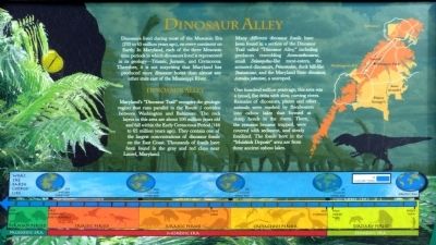
Dinosaurs lived during most of the Mesozoic Era (235 to 65 million years ago), on every continent on Earth. In Maryland, each of three Mesozoic time periods in which dinosaurs live is represented in its geology -- Triassic, Jurassic, and Cretaceous. Therefore, it is not surprising that Maryland has produced more dinosaur bones than almost any other state east of the Mississippi River.
Dinosaur Alley
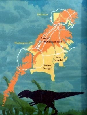
Maryland's "Dinosaur Trail" occupies the geologic region that runs parallel to the Route 1 corridor between Washington and Baltimore. The rock layers in this area are about 100 million years old and fall in the Early Cretaceous Period (144 to 65 million years ago). They contain one of the largest concentrations of dinosaur fossils on the East Coast. Thousands of fossils have been found in the gray and red clays near Laurel, Maryland.
Many different dinosaur fossils have been found in a section of the Dinosaur Trail called "Dinosaur Alley," including predators resembling Acroncanthosaurus, small Deinonychus-like meat eaters, the armored dinosaurs, Princonodon, duck bill-like Tentontosaur, and the Maryland State dinosaur, Astrondon johnstoni, a sauropod.
One hundred million years ago, this area was a broad, flat delta with slow, curving rivers. Remains of dinosaurs, plants and other animals were washed by floodwaters into oxbow lakes that formed at sharp bends in the rivers. There, the remains became trapped, were covered with sediment, and slowly fossilized. The Fossils here in the "Muirkirk Deposit" area are from these ancient oxbow lakes.
Erected by Maryland-National Capital Parks and Planning Commission.
Topics. This historical marker is listed in this topic list: Paleontology.
Location. This marker has been replaced by another marker nearby. It was located near 39° 4.248′ N, 76° 52.123′ W. Marker was in Laurel, Maryland, in Prince George's County. Marker could be reached from Mid Atlantic Blvd.. The marker is in Dinosaur Park. Touch for map. Marker was at or near this postal address: 13201 Mid Atlantic Boulevard, Laurel MD 20708, United States of America. Touch for directions.
Other nearby markers. At least 8 other markers are within walking distance of this location. Welcome to Dinosaur Park (here, next to this marker); The Dinosaurs of Dinosaur Park (here, next to this marker); The Industrial Heritage of Dinosaur Park (a few steps from this marker); Meet Astrodon johnstoni (a few steps from this marker); a different marker also named Welcome to Dinosaur Park (a few steps from this marker); George Washington Carver (approx. 0.4 miles away); Veterans Memorial (approx. 0.4 miles away); Three Sisters: Close Knit Communities of the Laurel Area (approx. 0.8 miles away). Touch for a list and map of all markers in Laurel.
Related marker. Click here for another marker that is related to this marker. This marker has been replaced by the linked marker.
Also see . . . Laurel area rich in dinosaur fossils is dedicated as a park. by Jonathan Mummolo, The Washington Post, Tuesday, October 27, 2009. (Submitted on July 30, 2013, by Allen C. Browne of Silver Spring, Maryland.)
Credits. This page was last revised on December 11, 2021. It was originally submitted on July 30, 2013, by Allen C. Browne of Silver Spring, Maryland. This page has been viewed 1,020 times since then and 53 times this year. Photos: 1, 2, 3, 4. submitted on July 30, 2013, by Allen C. Browne of Silver Spring, Maryland. • Bill Pfingsten was the editor who published this page.


