Buckingham in Buckingham County, Virginia — The American South (Mid-Atlantic)
Thomas Jefferson’s Lost Courthouse
A Research Project of the Longwood Archaeology Field School
Inscription.
“I have taken the liberty to trespass upon your time and talents (a common stock) which we all seem to have a right to draw upon, …to draft for us a plan of our Court house,…” Source: Letter from Colonel Charles Yancey to Thomas Jefferson
7
After the fire, the Justices of the Buckingham County Court appointed commissioners to see to the design and construction of a new courthouse as well as to:
“…take such steps as may seem necessary to them to preserve and secure from waste the materials of the old courthouse building and enclosure...”
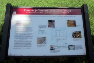
The evidence from Feature 1 clearly indicates that the brick foundations were harvested for usable, While the unsuitable bricks were discarded in the foundation trench, thus demonstrating that the commissioners were efficient in discharging their duty to preserve and secure the materials of the old courthouse, presumably for re-use in the new courthouse. Feature 1 also demonstrates that Jefferson’s courthouse was 12 feet wider than the courthouse that replaced it in 1873.
Since the west wall of the 1873 courthouse sits on the foundation of the west wall of the 1822 courthouse, it is possible, based on Feature 1, to conclude that Jefferson’s courthouse measured 52 feet in width or 12 feet wider than the 1873 courthouse. This width fits with the maximum width specified by Yancey in his July 12, 1821 letter to Jefferson, wherein he calls for a building between 48 and 52 feet square. Although Jefferson’s reply to Yancey on July 23, 1821 clearly states that his design went beyond the dimensions specified by Yancey, one is left to conclude that he did so in the length rather than the width.
Feature 2 was a shallow builder’s trench similar to the one encountered in the units to the west of the courthouse. The feature measured 16’4” north to south and turned to the east on each end. Feature 2 was locate 7’9” to the east of Feature 1 and was thus positioned in the correct place to be the east wing or pavilion. Unit 8 confirmed the presence of the shallow builder’s trench of the east wall of the pavilion. Unit 7 also contained the remains of a portion of brick walkway in situ between the east pavilion and the east wall of Jefferson’s courthouse, possibly indicating the placement of a side door into the courthouse.
Units 10 and 12 contained evidence of column foundations, one for a large column (unit 10) and one for a lesser column base (unit 12).
(captions)
Feature 1 was a deep builder’s trench full of brick rubble. The trench extended from the direction of the present courthouse to the east, a distance of 12 feet, before turning north and
continuing through Unit 7 and under the circuit court clerk’s office. Feature 1 was determined to be the builder’s trench of the east wall of Jefferson’s 1822 courthouse.
Unit 9 contained Features 3-6, all relating to the portico, the main columns and the lesser colonnade. Features 3 and 4 were shallow builder’s trenches presumably relating to the masonry floor of the portico and colonnade.
Feature 6 was a shallow foundation trench for a large column base. The column bases from Jefferson’s courthouse are located on the courthouse green and measure 40 inches square at the base. The foundation trench measured 44 inches square.
Unit 7 produced evidence of two linear brick rubble features (Feature 1 and Feature 2).
The area directly to the east of the courthouse was opened in one large excavation unit (unit 7) and two smaller units (units 6 & 8). Units 9, 10 and 12 were placed to the south of the sidewalk that extends to the east from the courthouse.
Feature 5 was the shallow foundation for a lesser colonnade column base. Evidence of the lesser columns was shared with the research team by Mr. H. Spencer Adams, whose grandfather was the last jailor in the county. Mr. Adams has four small column capitals that were recovered from the courthouse site by his grandfather.
Erected by Virginia Department of Historic Resources.
Topics and series. This historical marker is listed in these topic lists: Architecture • Government & Politics. In addition, it is included in the Former U.S. Presidents: #03 Thomas Jefferson series list. A significant historical month for this entry is July 1869.
Location. 37° 33.037′ N, 78° 33.395′ W. Marker is in Buckingham, Virginia, in Buckingham County. Marker can be reached from the intersection of West James Anderson Highway (U.S. 60) and Courthouse Road, on the right when traveling west. Touch for map. Marker is at or near this postal address: 13061 W James Anderson Hwy, Buckingham VA 23921, United States of America. Touch for directions.
Other nearby markers. At least 8 other markers are within 2 miles of this marker, measured as the crow flies. Buckingham County War Memorial (a few steps from this marker); a different marker also named Thomas Jefferson's Lost Courthouse (a few steps from this marker); a different marker also named Thomas Jefferson’s Lost Courthouse (a few steps from this marker); Confederate Soldiers of Buckingham County (within shouting distance of this marker); Buckingham Courthouse (approx. 0.3 miles away); a different marker also named Buckingham Courthouse (approx. one mile away); After Appomattox (approx. 1.7 miles away); One-Room Schoolhouse (approx. 1.8 miles away). Touch for a list and map of all markers in Buckingham.
Also see . . . Digging for Jefferson's Lost Courthouse. Smithsonian magazine, October 2004 (Submitted on August 5, 2013.)
Credits. This page was last revised on August 6, 2020. It was originally submitted on August 5, 2013, by Bernard Fisher of Richmond, Virginia. This page has been viewed 497 times since then and 39 times this year. Photos: 1, 2, 3. submitted on August 5, 2013, by Bernard Fisher of Richmond, Virginia.


