West Columbia in Lexington County, South Carolina — The American South (South Atlantic)
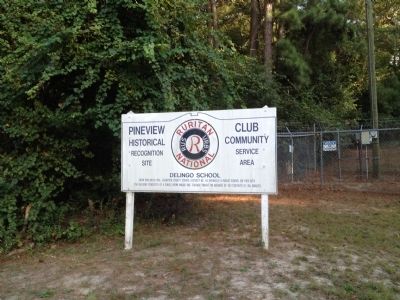
Delingo School
Pineview Historical Recognition Site
Erected by Ruritan National.
Topics. This historical marker is listed in this topic list: Education. A significant historical year for this entry is 1900.
Location. 34° 0.471′ N, 81° 8.191′ W. Marker is in West Columbia, South Carolina, in Lexington County. Marker is at the intersection of Sunset Boulevard (U.S. 378) and Pony Hill Road, on the right when traveling east on Sunset Boulevard. Touch for map. Marker is in this post office area: West Columbia SC 29169, United States of America. Touch for directions.
Other nearby markers. At least 8 other markers are within 4 miles of this marker, measured as the crow flies. Mt. Hebron United Methodist Church / Temperance Hall (approx. 0.9 miles away); Zion Lutheran Church / Dreher's Fort (approx. 1.4 miles away); St. Andrew's Lutheran Church (approx. 2.6 miles away); The Sycamore Tree (approx. 2.8 miles away); Saluda Factory Cemetery (approx. 2.9 miles away); The Cherokee Path (approx. 3 miles away); Saluda Factory Ruins (approx. 3.2 miles away); A Bridge to the Past (approx. 3˝ miles away). Touch for a list and map of all markers in West Columbia.
Credits. This page was last revised on June 16, 2016. It was originally submitted on October 21, 2013, by Kevin Vincent of Arlington, Virginia. This page has been viewed 669 times since then and 18 times this year. Photo 1. submitted on October 21, 2013, by Kevin Vincent of Arlington, Virginia. • Bernard Fisher was the editor who published this page.
