Arco in Butte County, Idaho — The American West (Mountains)
Get over it!
Craters of the Moon National Monument
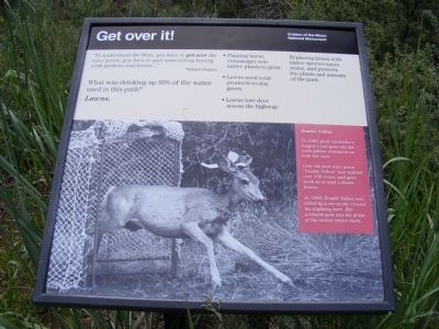
“To understand the West, you have to get over the color green; you have to quit associating beauty with gardens and lawns…” Wallace Stegner.
What was drinking up 80% of the water used in this park? Lawns.
• Planting lawns encourages non-native plants to grow.
• Lawns need toxic products to stay green.
• Lawns lure deer across the highway.
Replacing lawns with native species saves water, and protects the plants and animals of the park.
(Inscription next to the photo of the deer) Double Yellow-In 1980, park researchers tagged a two-year old doe with yellow streamers on both her ears.
Over the next nine years, “Double Yellow” was sighted over 100 times, and gave birth to at least a dozen fawns.
In 1989, Double Yellow was killed by a car as she crossed the highway here. Her probable goal was the grass of the visitor center lawn.
Erected by National Park Service, U.S. Department of the Interior.
Topics. This historical marker is listed in these topic lists: Animals • Horticulture & Forestry. A significant historical year for this entry is 1980.
Location. 43° 27.708′ N, 113° 33.714′ W. Marker is in Arco, Idaho, in Butte County. Marker is on Loop Road near the Park Entrance. Touch for map. Marker is in this post office area: Arco ID 83213, United States of America. Touch for directions.
Other nearby markers. At least 8 other markers are within 2 miles of this marker, measured as the crow flies. Where's the Volcano? (about 600 feet away, measured in a direct line); Just Down The Road (approx. 0.2 miles away); North Crater Flow Trail (approx. 0.3 miles away); North Crater Lava Flow (approx. 0.3 miles away); Vanishing Landmark (approx. 0.4 miles away); Devil's Orchard Trail (approx. 1.4 miles away); Silent Cone (approx. 1.4 miles away); Volcanoes Along the Rift (approx. 1.4 miles away). Touch for a list and map of all markers in Arco.
Credits. This page was last revised on December 4, 2022. It was originally submitted on December 5, 2013, by Don Morfe of Baltimore, Maryland. This page has been viewed 15,593 times since then and 9 times this year. Photos: 1, 2. submitted on December 5, 2013, by Don Morfe of Baltimore, Maryland. • Andrew Ruppenstein was the editor who published this page.

