Duboce Triangle in San Francisco City and County, California — The American West (Pacific Coastal)
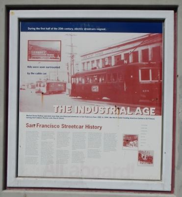
The Industrial Age
San Francisco Street Car History

Photographed By Barry Swackhamer, March 20, 2014
1. The Industrial Age Marker
Caption: Market Street Railway operated more than one thousand streetcars in San Francisco from 1921 to 1944, like this N-Judah heading downtown behind a 22-Fillmore turning from Duboce Avenue onto Church Street. (top center); The Industrial Age created the need for efficient urban transportation which came first in the form of horse-drawn vehicles.(lower right)
During the first half of the 20th century, electric streetcars reigned.
Hills were soon surmounted by the cable car.
The Industrial Age created the need for efficient urban transportation, which came first in the form of horse-drawn vehicles. During the first half of the 20th century electric streetcars reigned. The very popular PCC (Electric Railway Presidents’ Conference Commission) streetcar dominated in the 1930s, 40s, and 50s. This Art Deco-style car, designed by electric railway leaders to bring modern looks and technology to streetcars, was a familiar sight in many American cities. Following World War II many transit lines were converted from rail to buses. Streetcars and their tracks disappeared. More recent years have seen a renewed interest in urban rail transit with the LRV (light rail vehicle) replacing the venerable PCC.
The Gold Rush in 1849 transformed San Francisco from a sleepy outpost into a center of activity relating to mining and associated financial affairs. This new population created a need for public transit, which early on followed the typical pattern of horse-drawn omnibuses, horse-drawn railcar, and even the rail coach powered by a steam engine on Market Street. In 1872 Andrew Hallidie built and operated the world’s first successful cable car system in San Francisco and the city’s hilly terrain was conquered.
Electric transit began in 1891 with the development of the first section of interurban service from San Francisco to San Mateo. In 1906 when the cable car system was destroyed in the great earthquake, electric trolleys replaced all cable cars on Market Street. In 1912 the San Francisco Municipal Railway was formed to operate city owned transit lines. Privately-owned United Railroads, which became the Market Street Railway Company in 1921, operated competing lines. The Municipal Railway used letters to designate its lines, while the Market Street Railway used numbers. With competing tracks running side by side, Market Street became the famous four track thoroughfare known as the “roar of the four.”
Competition between the Municipal Railway and Market Street Railway continued for many years, but a merger of the two systems was inevitable. When the Municipal Railway opened the Twin Peaks tunnel in 1917 and the Sunset Tunnel in 1928, it gave the city-owned system a distinct advantage over Market Street Railway. The early 1940s saw the further decline of the Market Street Railway. In 1944 it was acquired by San Francisco Municipal Railway and faded into transit history.
Today Market Street’s F line offers the public an opportunity to experience urban transit history whether you’re on or off a streetcar. Running
in regular service are fully refurbished PCCs and Peter Witt streetcars, both sporting paint schemes of many U.S. cities that once had streetcar service. Supplementing this fleet in occasional service are antique trolleys dating as far back as 1895, as well as unusual trains from around the world.
From the western terminal on 17th Street at Castro Street, in the heart of the famous Castro Village neighborhood, F-line streetcars swinging onto Market Street. The tracks then flank stately Canary Island palm trees for six blocks to Valencia Street. Then the cars snake by the antique shops and cafes of mid-Market Street, with the galleries of Hayes Valley only a few blocks north. Next comes Civic Center, America’s greatest collection of beaux-arts municipal buildings, including the elegant City Hall, the new Main Public Library, and the new Asian Art Museum.
The trolleys then rumble through the canyons of downtown, passing many landmark buildings and the smart Union Square shopping area near the Powell Street cable car turntable. This is followed by the entry to Yerba Buena Garden, the city’s arts area containing Moscone Convention Center. The office towers and plazas of the Financial District are next. The streetcars continue down Market Street to Steuart Street, around the grand plaza in front of the Ferry Building, then north along The Embarcadero in an exclusive median again highlighted by palm trees. Past the wonderful bay views of Pier 7, Levi’s Plaza, and Telegraph Hill, the scenic run end five miles from its start. A long loop from Pier 39 through the heart of Fisherman’s Wharf brings the F-line to its terminal at Jones and Jefferson Streets, a short stroll from the Mason and Hyde cable car turntable.
The original Market Street Railway was a private transit company that operated more than one thousand streetcars in San Francisco from 1921 to 1944. Today its name is used by a nonprofit group whose members are dedicated to the preservation and operation of historic transit vehicles in San Francisco. The organization and its members have acquired and donated several vintage streetcars, cable cars and buses to the San Francisco Municipal Railway. Its volunteers assist Muni in restoring and maintaining the vintage transit fleet. They are also committed to helping make the city’s historic streetcar, cable car, and bus operations a continuing success through promotional efforts, liaison with business and neighborhood groups and other beneficial activities. For more information about Market Street Railway, visit their web site at www.streetcar.org or call (415) 863-1775.
Erected by Market Street Railway.
Topics and series. This historical marker is listed in this topic list: Railroads & Streetcars. In addition, it is included in the Art Deco series list. A significant historical year for this entry is 1849.
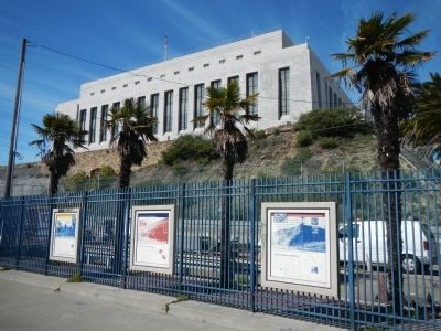
Location. 37° 46.176′ N, 122° 25.613′ W. Marker is in San Francisco, California, in San Francisco City and County. It is in Duboce Triangle. Marker is on Duboce Avenue near Market Street, on the right when traveling west. Touch for map. Marker is at or near this postal address: 312 Duboce Avenue, San Francisco CA 94114, United States of America. Touch for directions.
Other nearby markers. At least 8 other markers are within walking distance of this marker. King of the Road! (here, next to this marker); Mint Hill (a few steps from this marker); California Volunteers' Memorial (about 300 feet away, measured in a direct line); St. Francis Lutheran Church (about 800 feet away); Haight-Fillmore Building (approx. ¼ mile away); Swedish American Hall (approx. 0.3 miles away); Elixir (approx. 0.4 miles away); Site of Woodward's Gardens (approx. 0.4 miles away). Touch for a list and map of all markers in San Francisco.
More about this marker. This portion of Duboce Avenue is a bikeway.
Also see . . . Market Street Railway. San Francisco's Municipal Railway has assembled one of the most diverse collections of vintage streetcars, trolleys, and trams in transit service anywhere. Up to 20 of these vintage vehicles carry passengers along Market Street and The Embarcadero every day. (Submitted on March 30, 2014, by Barry Swackhamer of Brentwood, California.)
Credits. This page was last revised on February 7, 2023. It was originally submitted on March 30, 2014, by Barry Swackhamer of Brentwood, California. This page has been viewed 419 times since then and 20 times this year. Photos: 1, 2. submitted on March 30, 2014, by Barry Swackhamer of Brentwood, California. • Bill Pfingsten was the editor who published this page.
