Parkersburg in Wood County, West Virginia — The American South (Appalachia)
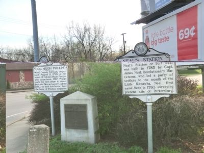
Col. Hugh Phelps
Erected 1974 by West Virginia Archives and History.
Topics and series. This historical marker is listed in this topic list: Settlements & Settlers. In addition, it is included in the West Virginia Archives and History series list. A significant historical year for this entry is 1799.
Location. 39° 15.28′ N, 81° 32.816′ W. Marker is in Parkersburg, West Virginia, in Wood County. Marker is at the intersection of Pike Street and Camden Avenue on Pike Street. Touch for map. Marker is in this post office area: Parkersburg WV 26101, United States of America. Touch for directions.
Other nearby markers. At least 8 other markers are within one mile of this marker, measured as the crow flies. Neal's Station (here, next to this marker); The Block-House (here, next to this marker); Tavenner Cemetery (approx. ¼ mile away); The Toll House (approx. 0.6 miles away); Old Tollgate House (approx. 0.6 miles away); Old Turnpikes (approx. 0.6 miles away); Carnegie Library (approx. 0.9 miles away); John J. Jackson, Jr. (approx. one mile away). Touch for a list and map of all markers in Parkersburg.
Credits. This page was last revised on June 16, 2016. It was originally submitted on May 11, 2014, by Don Morfe of Baltimore, Maryland. This page has been viewed 464 times since then and 33 times this year. Photos: 1, 2. submitted on May 11, 2014, by Don Morfe of Baltimore, Maryland. • Bill Pfingsten was the editor who published this page.

