Blair in Washington County, Nebraska — The American Midwest (Upper Plains)
Lewis and Clark Campsite Area

Photographed By Barry Swackhamer, May 26, 2014
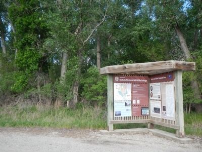
1. Lewis and Clark Campsite Area Marker
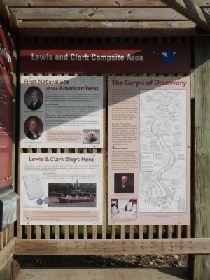
Captions on the First Naturalists of the American West plaque (top,left and bottom, left): Meriwether Lewis by Charles Wilson Peal, ca 180-1808. Courtesy Independence National Historical Park; William Clark by Charles Wilson Peal, ca 1807. Courtesy Independence National Historical Park.
Captions on the Lewis and Clark Slept Here plaque (left and right): August 3, 1804 The first expedition peace medals were distributed to Oto and Missouri leaders at “Council Bluff: before heading upriver to this location; A large keelboat and two smaller crafts called pirogues, were used on the slow moving upstream leg of the journey.
Captions on The Corps of Discovery plaque (bottom, left (above and below)): Lewis received instruction and advice in mathematics and astronomy from Robert Patterson, Irish-born professor of mathematics at the University of Pennsylvania; After the Corps of Discovery disbanded in 1806, many of Lewis and Clark’s journals were deposited in the collection of the American Philosophical Society at Thomas Jefferson’s urging.
Captions for the map on the right: You are standing in the vicinity of where the Corps of Discovery camped overnight, August 3, 1804. The map shows the pathway of the Missouri River as Lewis and Clark would have seen it, as well as the river’s current location. Enjoy reading excerpts from Lewis and Clark’s journals and their descriptions of the landscape. Compare their descriptions with what you see at DeSoto and Boyer Chute National Wildlife Refuges today; Explorations of Lewis and Clark 1804 - 1806. Cartographic Reconstruction Maps by Martin Plamodon UTM Zone 14, 15, Map Number 67 & 68 (Joined). Courtesy, Washington State University Press.
Three plaques are on this marker.
Top, left plaque
First Naturalists of the American West
The Lewis and Clark Expedition was more than a geographic expedition. Lewis; and Clark became the first scientists to document the natural history of the American West. They were careful and accurate observers. Lewis had been trained by experts of the time in natural history methods of collecting samples of plants and animals.
Scientific Discovery
Under orders from President Thomas Jefferson, Lewis and Clark accurately recorded observations about the geography, plants, animals and inhabitants of the country through which they passed. In this stretch of the river, William Clark noted the plentiful game in his journal ”Cat fish is Cought in any part of the river Turkey, Gees & a Beaver Killed and Cought…” They also recorded sightings of badger, great egret, lest tern and pine snake in the area near DeSoto and Boyer Chute refuges.
Today, the U.S. Fish and Wildlife Service manage many of the species documented by Lewis and Clark. Modern wildlife biologists still consult Lewis and Clark’s journals for information on the status of wildlife species over 200 years ago.
Side-bar at bottom:
The expedition’s second badger was recorded on July 30, 1804 at “Council Bluff" camp - near present-day Boyer Chute National Wildlife Refuge. The badger was probably the first zoological specimen preserved by Lewis on the expedition. Lewis skinned and stuffed the badger to send back to President Jefferson.
Bottom, left plaque
Lewis and Clark Slept Here
On the afternoon of August 3rd, after council with the Ota and Missouri tribes, the expedition traveled abut 5 miles north and set camp along the bank nearby thus location (south of the present town of Blair, Nebraska). The exact spot has never been determined. The campsite could be in Harrison County, Iowa, or Washington County, Nebraska depending on shifts of the river.
August 3, Friday 1804 “… at 4 oClock set out under a gentle Breeze from the S.E. proceeded on N. 5 (degrees) E. 5 Ms. passed a Pt. on the S.S. and round a large Sand bar on the L.S. and Camped above, below a great number of Snags quit (quite?) across the river. The Musquitors more numerous than I ever saw them, all in Spirrits…”
The Lewis and Clark Expedition traveled from Illinois to the Pacific Ocean and back between 18-4-1806. Over 100 years later, visitors can retake the expedition’s path by following the Lewis and Clark National Historic Trail. DeSoto and Boyer Chute National Wildlife Refuges are two of more than 100 sites along the Lewis and Clark National Historic Trail. Federal, state, tribal, local agencies and private organizations work together across more than 3,700 miles of trail to provide opportunities for visitors to experience and learn more about the Lewis and Clark Expedition.
Right plaque
The Corps of Discovery
In 1803, President Thomas Jefferson directed his personal secretary, Meriwether Lewis, and a young army officer, William Clark, to explore the course of the Missouri River in search of a water route to the Pacific Ocean. Leading an expedition called the Corps of Discovery, Lewis and Clark were instructed to document any new plants, animals, landforms, and people they saw along the way. Accompanied by 26 men, Lewis and Clark left their camp at River Dubois in Illinois, across from St. Louis, Missouri and the mouth of the Missouri River, on May 14, 1804.
By the end of their journey, on September 23, 1806, almost 8,000 miles and 28 months later, Lewis and Clark had described 178 plants, and 122 animals previously unknown to science. Many of these species are important to today’s biological arm of the federal government - the U.S Fish and Wildlife Service. Some of the species discovered are now endangered or threatened.
Preparing for Expedition
Thomas Jefferson, and other members of the American Philosophical Society (Philadelphia), instructed Lewis in the sciences. During the spring of 1803 Lewis studied medicine, preservation of plant and animal samples, the use of navigation instruments for determining latitude and longitude, and the study of fossils with the leading scientists of the day.
Erected by Fish and Wildlife Service, U.S. Department of the Interior.
Topics and series. This historical marker is listed in this topic list: Exploration. In addition, it is included in the Former U.S. Presidents: #03 Thomas Jefferson, and the Lewis & Clark Expedition series lists. A significant historical date for this entry is May 14, 1804.
Location. 41° 31.46′ N, 96° 0.117′ W. Marker is in Blair, Nebraska, in Washington County. Marker is on DeSoto Lake Road near Lakeview Drive, on the left when traveling east. Touch for map. Marker is in this post office area: Blair NE 68009, United States of America. Touch for directions.
Other nearby markers. At least 8 other markers are within 6 miles of this marker, measured as the crow flies. Steamboat Bertrand (approx. 1½ miles away); The Lewis and Clark Expedition (approx. 2 miles away); Up the Missouri (approx. 2 miles away); DeSoto Townsite (approx. 4.1 miles away); Lewis and Clark Campsite (approx. 4.8 miles away); Fort Atkinson (approx. 4.9 miles away); a different marker also named Fort Atkinson (approx. 5 miles away); The Death of Marshal Suverkrubbe (approx. 5.2 miles away). Touch for a list and map of all markers in Blair.
More about this marker. This marker is located on the eastern, unpaved portion of the DeSoto Lake Road loop.
Credits. This page was last revised on September 7, 2021. It was originally submitted on September 4, 2014, by Barry Swackhamer of Brentwood, California. This page has been viewed 593 times since then and 34 times this year. Photos: 1, 2. submitted on September 4, 2014, by Barry Swackhamer of Brentwood, California. • Bill Pfingsten was the editor who published this page.
