West Point in Fayette County, Texas — The American South (West South Central)
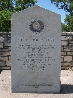
Site of Woods' Fort
a protection against Indian attacks
1828-1842
fortified residence of
Zadock Woods
veteran of the War of 1812
One of the old "Three Hundred"
of Austin's colonists
Oldest man killed in the
"Dawson Massacre"
September 18, 1842
Erected 1936 by State of Texas. (Marker Number 5902.)
Topics and series. This historical marker is listed in these topic lists: Forts and Castles • Settlements & Settlers. In addition, it is included in the Texas 1936 Centennial Markers and Monuments series list. A significant historical month for this entry is September 1843.
Location. 29° 56.486′ N, 97° 3.699′ W. Marker is in West Point, Texas, in Fayette County. Marker is on State Highway 71, on the right when traveling east. Touch for map. Marker is in this post office area: West Point TX 78963, United States of America. Touch for directions.
Other nearby markers. At least 8 other markers are within 6 miles of this marker, measured as the crow flies. Joseph C. Robinson (approx. half a mile away); Woods Prairie Cemetery (approx. 0.6 miles away); Old Plum Grove Cemetery (approx. 2.4 miles away); St. Peter Lutheran Church and Prairie Valley Cemetery (approx. 4 miles away); Saints Peter and Paul Old Catholic Cemetery (approx. 5.3 miles away); Shiloh Cemetery (approx. 5.7 miles away); Winchester Cemetery (approx. 5.7 miles away); Shiloh Missionary Baptist Church (approx. 5.7 miles away). Touch for a list and map of all markers in West Point.
Credits. This page was last revised on October 25, 2020. It was originally submitted on June 19, 2009, by Richard Denney of Austin, Texas. This page has been viewed 2,303 times since then and 126 times this year. Last updated on December 17, 2014, by Michael Heinich of Austin, Texas. Photos: 1, 2. submitted on June 19, 2009, by Richard Denney of Austin, Texas. • Bernard Fisher was the editor who published this page.

