Near Bowling Green in Warren County, Kentucky — The American South (East South Central)
Colonel Arnie Franklin USAF
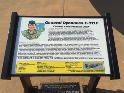
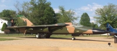
General Dynamics F-111F
Arnold L. "Arnie" Franklin, Jr. was born in Franklin, KY, and his family moved to Bowling Green, KY, when he was 10 years old. He graduated from Bowling Green High School in 1962 and Western Kentucky University in 1966. He joined the USAF immediately thereafter, completing Undergraduate Pilot Training in 1968.
During his Air Force career, he accumulated 3,500 flying hours, with a total of over 780 combat hours while flying OV-10s and F-111s in Southeast Asia and RAF Lakenheath, England. Annie held numerous command positions, including F-111 wing commander, and vice commander of Air University
He earned several military awards and decorations, including the Legion of Merit with one oak leaf cluster, the Distinguished Flying Cross with one oak leaf cluster, the Meritorious Service Medal with one oak leaf cluster, and the Air Medal with 15 oak leaf clusters.
OPERATION COLORADO CANYON
At 0200, 15 April 1986, Lieutenant Colonel Arnie Franklin, call sign Remit 31, led 18 General Dynamics F-111Fs out of the 48th Tactical Fighter Wing, stationed at Royal Air Force Station, Lakenheath, England, on a mission bombing three targets in and around Tripoli, the capital of Libya. The U.S. Navy simultaneously bombed two target areas near Benghazi, on the eastern shore of of the Gulf of Sidra. The objective of the mission was to demonstrate national resolve to combat state sponsored terrorism. The mission served as a warning against continued Libyan-sponsored terrorist attacks around the world. The grueling mission lasted more than 14 hours with numerous air-to-air refuelings.
The F-111F aircraft that Lt Col Franklin flew on the mission, tail number 70-2390, is on display at the National Museum of the U.S. Air Force at Wright-Patterson AFB in Dayton, Ohio. The aircraft on display here at Aviation Heritage Park also participated in the raid, flying on Franklin's wing, with call sign Remit 33. It went on to participate in Desert Storm, flying 56 sorties in 46 nights. This aircraft was retired from active duty and flown to the bone yard in Tucson, Arizona on 29 July 1996, where it remained until taken out of storage by Aviation Heritage Park in 2012. It is painted as it looked when it launched on El Dorado Canyon.
Crew: 2 (pilot and weapons system officer)
Length: 73 ft 6 in
Wingspan:
Spread: 63 ft
Swept: 32 ft
Height: 17 ft
Weight:
Empty: 49,500 lb
Full fuel: 82,800 lb
Max take-off weight: 100,000 lb
Powerplant: 2 X Pratt & Whitney TF-30-P-100 turbofans
Military thrust: 17,900 lbf each
Max afterburner: 25,100 lbf each
Max Speed: Mach 2.5 at altitude
Combat radius: 1,330 miles
Ferry range: 4,200 miles
Service ceiling: 66,000 ft
Armament: 20mm M61 Vulcan 6-barreled gatling cannon
Armament capacity: A mix of up to 24 conventional or nuclear weapons mounted externally on hard points or internally in weapons bay.
Erected 2013 by the Bowling Green Aviation Heritage Center.
Topics and series. This historical marker is listed in these topic lists: Air & Space • War, 1st Iraq & Desert Storm • War, Vietnam. In addition, it is included in the Valor in Aerial Operations series list. A significant historical date for this entry is April 15, 1986.
Location. 36° 55.18′ N, 86° 26.106′ W. Marker is near Bowling Green, Kentucky, in Warren County. Marker can be reached from the intersection of Three Springs Road and Smallhouse Road. Touch for map. Marker is at or near this postal address: 1825 Three Springs Road, Bowling Green KY 42104, United States of America. Touch for directions.
Other nearby markers. At least 8 other markers are within 3 miles of this marker, measured as the crow flies. Grumman F9F-5 Panther (a few steps from this marker); Brigadier General Edward Cherry, USAF (within shouting distance of this marker); Col. Terrence ("Terry") W. Wilcutt, USMC (within shouting distance of this marker); Lockheed T-33A-5 Shooting Star (within shouting distance of this marker); Jacob Skiles and Three Springs (approx. ¼ mile away); McFadin's Station / Cumberland Trace (approx. 2 miles away); John Hunt Morgan (approx. 2.9 miles away); Lost River Blue Holes, Trees, Wild Flowers And Quarrying Ruins (approx. 3 miles away). Touch for a list and map of all markers in Bowling Green.
Also see . . . Bowling Green Aviation Heritage Park is on the Grow. (Submitted on June 10, 2015, by Mark Hilton of Montgomery, Alabama.)
Credits. This page was last revised on November 25, 2023. It was originally submitted on June 10, 2015, by Mark Hilton of Montgomery, Alabama. This page has been viewed 558 times since then and 32 times this year. Photos: 1, 2, 3. submitted on June 10, 2015, by Mark Hilton of Montgomery, Alabama.


