Downtown Kansas City in Jackson County, Missouri — The American Midwest (Upper Plains)
The French Bottoms - Early Day Kansas City
Inscription.
English Side
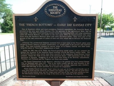
One of America’s oldest and most prestigious livestock expositions, the American Royal, is situated in the very spot where Kansas City, the gateway to the agricultural West, had its beginnings. This little French-speaking enclave below the imposing bluffs, still today sometimes called the French Bottoms, was settled in the very early 1800’s by French-Indians who came down from the Northern Missouri River with their Blackfoot wives. They were part of the genesis of the vast cornucopia of riches of food and fiber which was to become the American West.
A Kansas City architectural historian surmised that at least some of the French cabins were of typical French “poteaux en terre” construction, i.e., upright posts in the ground, with thatched roofs. They were probably situated on narrow strips, as in France, Canada, and Saint Louis, using the arpent of “Paris Acre” measurement of land.
Using the 1841 map of Fr. Point, the French-speaking parish priest, we can compare the present day locations of the American Royal buildings vis-à-vis the French settles’ farms. The Prudhomme/Mercier plot would have been nearest to the American Royal/Kemper Arena complex. Nearer the “bulls on the hill” at Genessee Street – I-670 intersection was the little farmstead of Edouard. Straggling on to the North were those of the Bowirds, LaGautheries, Trembles, and Philberts and the Tugeons and Etues were nearby.
The French Commandant of the Missouri, referring to the general area from present Kansas City on Westward said, circa 1717: “This is the finest country and the most beautiful in the world; the prairies are like the seas, and filled with wild animals, especially oxen (buffalo), cattle, hind and stag, in such quantities as to surpass the imagination.”
These country French had week “bals” where the tasty pot de boullion and friendly cup of wine went round and the chansons and fiddles and laughter rang out. But after the great flood of 1844, all was washed away, and the village priest said that all one could hear wafting up from the little French clearings were the songs of the birds and the chattering of the squirrels.
French Side
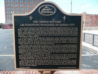
L’une des plus anciennes et prestigieuses foires expositions agricoles d'Amérique, l'American Royal, est situé à l'endroit même où la ville de Kansas City, porte de l'Ouest agricole, a été fondée. Cette petite enclave francophone située à l’abri d’imposantes falaises, aujourd'hui encore parfois appelées les “French Bottoms ”, a été étable au début des années 1800 par des indiens français descendus du Nord de la rivière Missouri avec leurs
épouses issues de la tribu “Blackfoot ”. Ils sont à l’origine de l’énorme corne d'abondance de produits alimentaires qu'allait devenir l'Ouest américain.
Un historien architecte de Kansas City a estimé qu'un moins certain nombre d'habitations étaient alors de type "poteaux en terre". D'un style typiquement français, elles étaient construites sur des poteaux enfoncés dans le sol et recouvertes de toits de chaume. Elles étaient probablement bàties sur de petites parcelles, comme en France, au Canada et à Saint-Louis, en utilisant l'arpent ou l'acre de Paris comme unité de mesure.
L'observation d'une carte établie en 1841 par Fr. Point, curé de la paroisse francophone, permet de situer l'emplacement des fermes des colons français sur celui actuel des bàtiments de l'Américain RoyalKemper Arena. Le terrain des Prudhomme/Mercier devait etre le plus proche de l'actuel complexe American Royal/Kemper Arena. Tout près du lieu-dit "Bulls on the Hill" à l'intersection de la rue Genessee et de l'autoroute I 670 se trouvait la petite ferme des Edouard. Disséminés plus au Nord, se trouvaient les domaines des Bowird, La Gautherie, Tremble et Philbert. Les Turgeon et Etue étaient aussi tout prés.
Le Commandant français du Missouri, évoquant l'ensemble de la région s'étendant de Kansas City vers l'Ouest, déclarait en 1717: "Ce pays est le plus pur et
le plus beau du monde; les prairies ressemblent à la mer et abondent de toutes sortes d'animaux en liberté, tout particulièrement des bisons, des bisons, des biches et des cerfs en des quantités inimaginables".
Les fermiers français organisaient chaque semaine des bals où le savoureux Èpot de boullion" et l'amicale verre de vin circulaient alors que fusaient rires et chansons accompagnés par des violons. Tout fut hélas emporté par la terrible inondation de 1844, tout a été emporté , le prètre du village déclarant alors que seuls les chants des oiseaux et le bavardage des écureuils s'échappaient.
Erected by Chouteau Society & the Mildred Lane Kemper Fund.
Topics. This historical marker is listed in this topic list: Settlements & Settlers. A significant historical year for this entry is 1841.
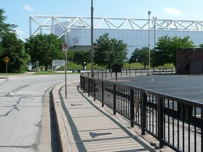
Location. 39° 5.613′ N, 94° 36.307′ W. Marker is in Kansas City, Missouri, in Jackson County. It is in Downtown Kansas City. Marker is on Genessee Street, on the right when traveling south. Touch for map. Marker is in this post office area: Kansas City MO 64102, United States of America. Touch for directions.
Other nearby markers. At least 8 other markers are within walking distance of this marker. Kansas City Stock Yards (about 400 feet away, measured in a direct line); The American Royal (approx. 0.2 miles away); Andrew Drips Park (approx. half a mile away); Kansas City (approx. 0.6 miles away); The Old French Cemetery (approx. 0.9 miles away); Lynching in America / Lynching of Levi Harrington (approx. 0.9 miles away); Chez Les Canses or "Chouteau's" (approx. 0.9 miles away); Chouteau’s Church (St. Francis Regis) (approx. one mile away). Touch for a list and map of all markers in Kansas City.
Credits. This page was last revised on February 10, 2023. It was originally submitted on July 27, 2015, by Michael W. Kruse of Kansas City, Missouri. This page has been viewed 731 times since then and 43 times this year. Photos: 1, 2, 3. submitted on July 27, 2015, by Michael W. Kruse of Kansas City, Missouri. • Bill Pfingsten was the editor who published this page.


