South Redondo in Redondo Beach in Los Angeles County, California — The American West (Pacific Coastal)
The Redondo Beach Plan
Photographed by Michael Kindig, March 25, 2016
1. The Redondo Beach Plan Marker
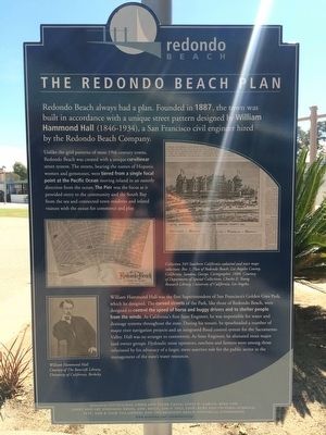
Unlike the grid patterns of most 19th century towns, Redondo Beach was created with a unique curvilinear street system. The streets, bearing the names of Hispanic women and gemstones, were tiered from a single focal point at the Pacific Ocean moving inland in an easterly direction from the ocean. The Pier was the focus as it provided entry to the community and the South Bay from the sea and connected town residents and inland visitors with the ocean for commerce and play.
William Hammond Hall was the first Superintendent of San Francisco Golden Gate Park, which he designed. The curved streets of the Park, like those of Redondo Beach, were designed to control the speed of horse and buggy drivers and to shelter people from the winds. As California's first State Engineer, he was responsible for water and drainage systems throughout the state. During his tenure, he spearheaded a number of major river
this page online
Erected 2009 by Councilman Chris and Diane Cagle; Louis N. Garcia; Mike Gin; Janet and Art Johnson; Ernie, Ann, Erica, Tim O'Dell 2008; Kurt and Victoria Schmalz; Pete, Sam & Nick Villasenor; and the Redondo Beach Historical Commission. (Marker Number 21.)
Topics. This historical marker is listed in this topic list: Industry & Commerce. A significant historical year for this entry is 1887.
Location. 33° 50.722′ N, 118° 23.301′ W. Marker is in Redondo Beach, California, in Los Angeles County. It is in South Redondo. It is on Elana Avenue, on the left when traveling north. Touch for map. Marker is in this post office area: Redondo Beach CA 90277, United States of America. Touch for directions.

Regionally, this marker is in Greater Los Angeles and in the Transverse
Photographed by Michael Kindig, March 25, 2016
2. The Redondo Beach Plan Marker
Other nearby markers. At least 8 other markers are within 2 miles of this marker, measured as the crow flies: 9-11 Tribute (within shouting distance of this marker); King Harbor and The Marinas (approx. 0.3 miles away); The Plunge and The Lightning Racer (approx. 0.3 miles away); Bill and Bob Meistrell (approx. 0.3 miles away); George Freeth (approx. 0.4 miles away); Hotel Redondo (approx. 0.6 miles away); Old Salt Lake (approx. 0.7 miles away); The First Bank of Hermosa Beach (approx. 1.3 miles away). Touch for a list and map of all markers in Redondo Beach.
Credits. This page was last revised on January 30, 2023. It was originally submitted on March 26, 2016, by Michael Kindig of Elk Grove, California. This page has been viewed 819 times since then and 50 times this year. Last updated on March 29, 2016, by Michael Kindig of Elk Grove, California. Photos: 1, 2. submitted on March 26, 2016, by Michael Kindig of Elk Grove, California. • Syd Whittle was the editor who published this page.
