
Toledo in Lucas County, Ohio — The American Midwest (Great Lakes)
Michigan - Ohio State Line
Ohio Revolutionary Memorial Trail
| — | Hull-Winchester Marches | — |

Image courtesy of the Historical Marker Database
1. Michigan - Ohio State Line Marker
Revolutionary
Memorial
Trail
Text on North Side :
1812 • Marches • 1813
- - - - -
Michigan
—
Ohio
State Line
Text on South Side :
1812 • Marches • 1813
- - - - -
Ohio
—
Michigan
State Line
Erected 1930 by Ohio Revolutionary Memorial Commission. (Marker Number A86.)
Topics and series. This historical marker is listed in this topic list: War of 1812. In addition, it is included in the Ohio Revolutionary Memorial Commission series list.
Location. Marker is missing. It was located near 41° 43.855′ N, 83° 31.885′ W. Marker was in Toledo, Ohio, in Lucas County. It was on North Detroit Avenue south of Benore Road, on the right when traveling north. Nothing remains of this marker, but it originally was situated just south of the Ohio - Michigan border, most probably on the east side of the road, where it appears that the base of one of the ORMC marker posts broke off at ground level.. Touch for map. Marker was in this post office area: Toledo OH 43612, United States of America. Touch for directions.

Regionally, this marker was on Ohio’s Lake Erie Shore. It was also in the American Midwest, on the Great Lakes, and in the Corn Belt. Globally, it was in North America, the Western Hemisphere, the Western World, and the Anglosphere. Historically, it found itself in what was once the Viceroyalty of New France, the Haudenosaunee (Iroquois) Confederacy, the territory of the Mississippian Culture, and the Northwest Territory.
Other nearby markers. At least 8 other markers are within 4 miles of this location, measured as the crow flies: Historic Banner Oak School (approx. 1.6 miles away in Michigan); Howard Pinkley (approx. 2.4 miles away); Washington Township Veterans Monument
this page online
More about this marker. This historical marker is part of the Ohio Revolutionary Memorial Trail series (type A) which was put in place in 1930 to celebrate the 150th anniversary of the Ohio's Revolutionary War era Battle of Piqua, by the Ohio Revolutionary Memorial Commission.
In order to accomplish this, in 1929 the state of Ohio created the Ohio Revolutionary Memorial Commission, and then in 1930 this commission created 22 military trails, throughout western Ohio, between Cincinnati, Ohio on the state's southern border and Toledo, Ohio on the state's northern border. Each of these military trails represented the routes, or trails, used by military leaders during either the Revolutionary War, the Indian Wars, or the War of 1812. Each of these military routes connected various related historical
Photographed by Dale K. Benington, April 4, 2016
2. Michigan - Ohio State Line Marker
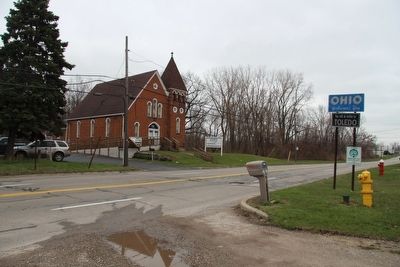
View of the probable marker site (about midway between the telephone pole and the larger pine tree), looking south along Detroit Avenue, from the Michigan side of the state line (see "Ohio Welcomes You" sign on right side of picture).
The routes of these military trails were in turn marked by type A and type B Ohio Revolutionary Memorial Commission markers that served as directional (type B) and distance (type A) markers. This particular marker is one of the type A markers of the Ohio Revolutionary Memorial Trail series.
Originally, back in 1930, according to the ORMC 1931 Planning Report, there were erected 168 some of these Ohio Revolutionary Memorial Commission, type A, markers (see page 54). To date, I know of only 3 of these type A markers that have been located and posted on the Historical Marker database (markers A95, A96, and A1340). A large number of them are presently missing, including this particular marker.
Also see . . . Ohio Revolutionary Memorial Commission. Historical Marker Project website entry (Submitted on March 10, 2022, by Larry Gertner of New York, New York.)
Additional commentary.
1. Ohio Revolutionary Memorial Trail System.
This particular Ohio Revolutionary Memorial Commission (ORMC), Type A
Photographed by Dale K. Benington, April 4, 2016
3. Michigan - Ohio State Line Marker
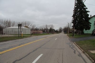
View looking north along Detroit Avenue, from the Ohio side of the state line. Picture yourself back to 1930, the two traffic lanes on the left side of the picture are gone, and on the right hand curb, just beyond the telephone pole is where our marker would be standing.
Back in 1930, when this marker was originally erected, US 25 was most likely a two lane roadway, whereas today, it is a four lane roadway. But other than that, it would "seem" that very little has changed with this fairly remote segment of roadway since 1930.
Along some portions of the Ohio Revolutionary Memorial Trail System, it is difficult to identify the probable location of these markers because the roadways of 1930 are so much different from the present day roadways. Many of the original roadways have been re-routed or by-passed, or in some cases given new route number
Photographed by Dale K. Benington, April 4, 2016
4. Michigan - Ohio State Line Marker
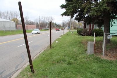
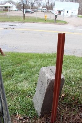
Close-up view, looking north, of the probable marker site, which is just beyond the grounded pole support cable. Note the short stone monument, marking the Ohio-Michigan State Line, to the right of the picture.
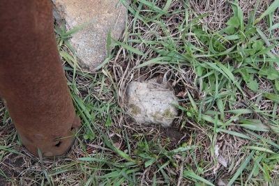
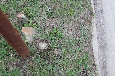
I would like to add that I located, right where I supposed that the ORMC marker had been situated, what appears to be the bottom portion of a cement support post, broken off right at ground level. It appears to made out of the same material, with very similar width dimensions, as the sole remaining support post for ORMC, type A marker A124, that is still standing at Hood Park, in downtown Perrysburg. I included a picture of the top of what I believe was the broken post segment.
— Submitted April 4, 2016, by Dale K. Benington of Toledo, Ohio.
Photographed by Dale K. Benington, April 4, 2016
5. Michigan - Ohio State Line Marker
View looking straight down. To the left is the metal tube that surrounds and protects a grounded pole support cable. In the center of the picture is the top of, what very well may be, the support post of the missing ORMC, Type A, marker. The support pole has been broken off at ground level.
Photographed by Dale K. Benington, April 4, 2016
6. Michigan - Ohio State Line Marker
View looking straight down, from slightly farther away, showing both the probable broken ORMC, Type A, marker pole, and its position relative to the nearby street curb.
Photographed by Dale K. Benington, April 4, 2016
7. Michigan - Ohio State Line Marker
View, looking west along the state line, of the short stone monument, that marks the border between Ohio - Michigan. The missing ORMC marker was just west of this stone monument, near the edge of the street.
Photographed by Ohio Revolutionary Memorial Commission
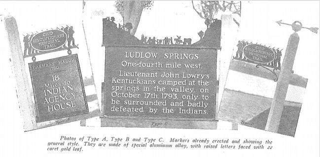
8. Ohio Revolutionary Memorial Commission Marker Types
View of the three types of markers used by the Ohio Revolutionary Memorial Commission. The marker on the left is a type A marker (just like our missing marker), the marker in the middle is a type C, and the marker on the right is a type B.
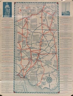
Image courtesy of the MidPointe Library System (www.MidPointeLibrary.org)
9. Ohio Revolutionary Memorial Trail Map
A view of an original Ohio Revolutionary Memorial Trail Map, from 1930. For a better view double click on this picture.
Credits. This page was last revised on March 11, 2022. It was originally submitted on April 4, 2016, by Dale K. Benington of Toledo, Ohio. This page has been viewed 1,111 times since then and 51 times this year. Photos: 1, 2, 3, 4, 5, 6. submitted on April 5, 2016, by Dale K. Benington of Toledo, Ohio. 7, 8, 9. submitted on April 7, 2016, by Dale K. Benington of Toledo, Ohio.
