Lower Township in Cape May County, New Jersey — The American Northeast (Mid-Atlantic)
The Bunker Story
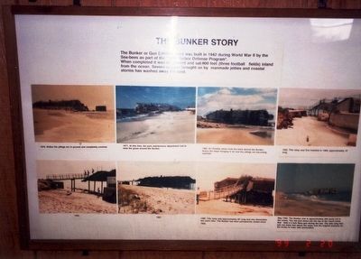
Photographed by Don Morfe, February 20, 1999
1. The Bunker Story Marker
The Bunker or Gun Emplacement was built in 1942 during World War II by the Sea-bees as part of the “Harbor Defense Program”.
When completed it was on ground and sat 900 feet (three football fields) inland from the ocean. Severe erosion brought on by manmade jetties and coastal storms has washed away the land.
Topics. This memorial is listed in this topic list: War, World II.
Location. 38° 55.889′ N, 74° 57.339′ W. Memorial is in Lower Township, New Jersey, in Cape May County. It is on Lighthouse Road. The marker is located in Cape May Point State Park near the parking lot. Touch for map. Memorial is at or near this postal address: 618 Seagrove Ave, Cape May Point NJ 08212, United States of America. Touch for directions.

Regionally, this memorial is on New Jersey’s Jersey Shore. It is also in the American Northeast, in the Mid-Atlantic, and on the Eastern Seaboard. Globally, it is in the North Atlantic Region, North America, the Western Hemisphere, the Western World, and the Anglosphere. Historically, it finds itself in what was once New Netherland
this page online
Other nearby markers. At least 8 other markers are within walking distance of this marker: Bats on the Move (about 700 feet away, measured in a direct line); Ridges, Rivers and Coastlines (about 800 feet away); Shorebirds Galore (approx. 0.2 miles away); What is it? (approx. 0.2 miles away); Flipper and Friends (approx. 0.2 miles away); Longshore Sediment Movement (approx. 0.2 miles away); Swarms of Dragonflies (approx. 0.2 miles away); Fragile Flyers (approx. 0.2 miles away). Touch for a list and map of all markers in Lower Township.
Another marker is no longer nearby. What Is It? (was here, next to this marker but has been permanently removed).
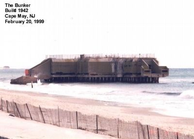
Photographed by Don Morfe, February 20, 1999
2. The Bunker
Credits. This page was last revised on February 7, 2023. It was originally submitted on May 2, 2016, by Don Morfe of Baltimore, Maryland. This page has been viewed 372 times since then and 13 times this year. Photos: 1, 2. submitted on May 2, 2016, by Don Morfe of Baltimore, Maryland. • Bill Pfingsten was the editor who published this page.
