
Franklin in Oakland County, Michigan — The American Midwest (Great Lakes)
Robert E. Cornillie's Vision
Photographed by Joel Seewald, October 15, 2016
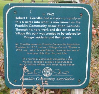
1. Robert E. Cornillie's Vision Marker
Mr. Cornillie served as Franklin Community Association President in 1967 and as Village Council Trustee in 1963-64. With his wife Patricia, he raised two sets of twin boys, Rob, Ron, Jim, and John.
The Franklin Community Association and Franklin Baseball League acknowledges Mr. Cornillie's efforts with much appreciation.
Erected by Franklin Community Association.
Topics. This historical marker is listed in this topic list: Charity & Public Work. A significant historical year for this entry is 1962.
Location. 42° 31.519′ N, 83° 18.429′ W. Marker is in Franklin, Michigan, in Oakland County. It is at the intersection of Carol Avenue and Normandy Road, on the left on Carol Avenue. Touch for map. Marker is in this post office area: Franklin MI 48025, United States of America. Touch for directions.

Regionally, this marker is in Southeast Michigan and in
this page online
Other nearby markers. At least 8 other markers are within 2 miles of this marker, measured as the crow flies: Kreger Farm Buildings (within shouting distance of this marker); Franklin Community Church (within shouting distance of this marker); Franklin Village (about 300 feet away, measured in a direct line); Franklin Village School (about 800 feet away); Franklin Cemetery (approx. 0.2 miles away); Van Every Gristmill (approx. 0.4 miles away); Congregation Beth El / Temple Beth El (approx. 1.1 miles away); Fractional District School (approx. 1.7 miles away). Touch for a list and map of all markers in Franklin.

Photographed by Joel Seewald, October 15, 2016
2. Robert E. Cornillie's Vision Marker
Credits. This page was last revised on October 15, 2016. It was originally submitted on October 15, 2016, by Joel Seewald of Madison Heights, Michigan. This page has been viewed 540 times since then and 41 times this year. Photos: 1, 2. submitted on October 15, 2016, by Joel Seewald of Madison Heights, Michigan.
