Mount Jewett in McKean County, Pennsylvania — The American Northeast (Mid-Atlantic)
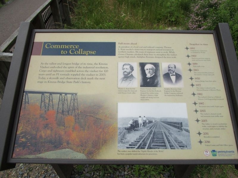
Commerce to Collapse
Full steam ahead. As president of a local coal and railroad company, Thomas L. Kane needed a faster way to transport natural resources to northern markets. His team of engineers went to work. While Octave Chanute calculated sheer force to strengthen the viaduct against high winds, Aldolphus Bonzano designed the iron work.
Thomas L. Kane had the vision to span the steep and wide Kinzua Creek Valley. -Perry Special Collections, Harold B. Lee Library, Brigham Young University. Octave Chanute, Chief Engineer for the Erie Railroad, designed the viaduct using Phoenix Columns, a light weight and strong cast iron truss system. Adolphus Bonzano, Chief Engineer for the Phoenix Bridge Company, embraced the engineering challenges. - Historical Society of the Phoenixville Area.
The viaduct, once dubbed the "Eighth Wonder of the World," has been a popular tourist attraction for generations.
Snapshot in time.
+ 1882 Original iron construction is completed in 94 days.
+ 1900 Steel reconstruction supports more and heavier train traffic.
+ 1959 Train traffic stops.
+ 1963 The commonwealth purchases the land for a future state park.
+ 1970 Kinzua Bridge State Park opens.
+ 1977 The viaduct is placed on the National Register of Historic Places.
+ 1982 The viaduct is listed as a National Historic Civil Engineering Landmark.
+ 1987 Excursion train traffic begins again.
+ 2002 The viaduct is deemed unsafe and excursion train traffic stops.
+ 2003 The viaduct is closed to pedestrian traffic, work begins to stabilize the structure, and a tornado strikes.
+ 2011 Skywalk is completed.
+ 2016 Visitor Center and Park Office opens.
Erected by Pennsylvania Wilds, Pennsylvania Department of Conservation and Natural Resouces.
Topics and series. This historical marker is listed in these topic lists: Bridges & Viaducts • Charity & Public Work • Disasters • Railroads & Streetcars. In addition, it is included in the ASCE Civil Engineering Landmarks series list. A significant historical year for this entry is 2003.
Location. 41° 45.59′ N, 78° 35.278′ W. Marker is in Mount Jewett, Pennsylvania, in McKean County. Marker can be reached from Viaduct Road near Lindholm Road (County Route 3011). Touch for map. Marker is at or near this postal address: 296 Viaduct Road, Mount Jewett PA 16740, United States of America. Touch for directions.
Other nearby markers.
At least 8 other markers are within 8 miles of this marker, measured as the crow flies. Sites to See (within shouting distance of this marker); Spanning History (within shouting distance of this marker); Forces of Nature (about 300 feet away, measured in a direct line); Kinzua Viaduct (about 300 feet away); Kinzua Bridge (about 600 feet away); Nebo Lutheran Chapel and Cemetery (approx. 4.3 miles away); Great Events in Smethport History (approx. 7.9 miles away); a different marker also named Great Events in Smethport History (approx. 8 miles away). Touch for a list and map of all markers in Mount Jewett.
Credits. This page was last revised on July 2, 2017. It was originally submitted on July 2, 2017, by Anton Schwarzmueller of Wilson, New York. This page has been viewed 283 times since then and 6 times this year. Photos: 1, 2. submitted on July 2, 2017, by Anton Schwarzmueller of Wilson, New York.

