Riggins in Idaho County, Idaho — The American West (Mountains)
Riggins in the 1940s
Beacons on Highway 95
ó Salmon River Heritage Waking Tour ó

Photographed By Barry Swackhamer, May 4, 2018
1. Riggins in the 1940s Marker
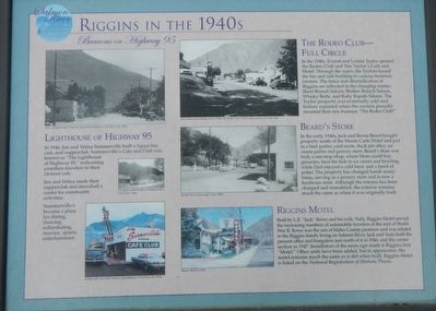
Captions: (top left) View of Summerville's Cafe, the cinder block building on the left, in the 1940s.; (middle left) The Riggs Mercantile and Summerville's Cafe in the 1940s.; (bottom left) Summerville's was still a beacon on along Highway 95 well into the 1970s.; (top center) View of downtown Riggins in the 1950s. The Rodeo Club with its large awning is on the right.; (center) Beard's Store on the right in the 1950s.; (bottom center) Riggins Motel in 2002.
In 1946, Jim and Velma Summerville built a liquor bar, cafe, and supperclub. Summervilleís Cafe and Club was known as “The Lighthouse of Highway 95,” welcoming countless travelers to their 24-hour cafe.
Jim and Velma made their supperclub and dancehall a center for community activities.
Summervilleís became a place for dining, dancing, rollerskating, movies, sports, entertainment.
The Rodeo Club - Full Circle
In the 1940s, Everett and Lorene Taylor opened the Rodeo Club and Tim Taylorís Cafe and Motel. Through the years, the Taylors leased the bar and cafe building to various business owners. The times and diversification of Riggins are reflected in the changing names: Short Branch Saloon, Broken Branch Saloon, Whisky Butte, and Ruby Rapids Saloon. The Taylor property was eventually sold and history repeated when the owners proudly renamed their new business “The Rodeo Club!”
Beardís Store
In the early 1940s, Jack and Bessie Beard bought property south of the Monte Carlo Hotel and put in a beer parlor, card room, duck pin alley, ice cream parlor and grocery store. Beardís Store was truly a one-stop-shop, where Mom could buy groceries, treat the kids to ice cream and bowling, while Dad enjoyed a cold brew and a hand of poker. The property has changed hands many times, serving as a grocery store and is now a hardware store. Although the interior has been changed and remodeled, the exterior remains much the same as when it was originally built.
Riggins Motel
Built by L.E. “Jack” Rowe and his wife, Veda, Riggins Motel served the increasing numbers of automobile travelers at the end of World War II. Rowe was the sone of Idaho County pioneers and was related to the Riggins family living on Salmon River. Jack and Veda built the present office and bungalow just north of it in 1946, and the center section in 1947. Installation of the neon sign made it Riggins first “Motel.” Other units have been added, but in appearance, the motel remains much the same as it did when built. Riggins Motel is listed on the National Registration of Historic Places.
Erected by City of Riggins.
Topics. This historical marker is listed in this topic list: Industry & Commerce. A significant historical year for this entry is 1946.
Location. 45° 25.308′ N, 116° 18.912′ W. Marker is in Riggins, Idaho, in Idaho County. Marker is at the intersection of Main Street (U.S. 95) and Lodge Street, on the left when traveling north on Main Street. Touch for map. Marker is at or near this postal address: 214 Main Street, Riggins ID 83549, United States of America. Touch for directions.
Other nearby markers. At least 8 other markers are within walking distance of this marker. Early Businesses (here, next to this marker); Riggins' Early Hotels (within shouting distance of this marker); The Evolution of a River Terrace (within shouting distance of this marker); Clay's Swinging Bridge (about 300 feet away, measured in a direct line); Educating Riggins' Children (about 400 feet away); The Forest Service (about 500 feet away); Gouge-Eye Legend (about 600 feet away); Youíve Got Mail (about 700 feet away). Touch for a list and map of all markers in Riggins.
Credits. This page was last revised on June 29, 2018. It was originally submitted on June 28, 2018, by Barry Swackhamer of Brentwood, California. This page has been viewed 229 times since then and 27 times this year. Photos: 1, 2. submitted on June 28, 2018, by Barry Swackhamer of Brentwood, California.
