Fort Mifflin in Philadelphia in Philadelphia County, Pennsylvania — The American Northeast (Mid-Atlantic)
Citadel - 1796
Commandantís House Ė 1835
Citadel
Report from the War Office
16 January 1796 ē Timothy Pickering, Secretary of War
A fort, on Mud Island, is about half done, and a Citadel has been erected to complete the fort Ö
Report from the Fort
21 January 1802 ē Major J. J. Ulrich Rivardi
The Citadel of brick, one story high 70 feet by 34 contains one room 27 by 27 – two rooms 20 by 15, two smaller ones, one kitchen and a porch. The garret is surrounded by a gallery and a breastwork of brick, but no defense could be expected from that building, as an enemy can stand all round close to the wall without the least injury. That building has settled considerably and the walls round the chimneys are in some places one inch open.
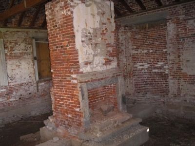
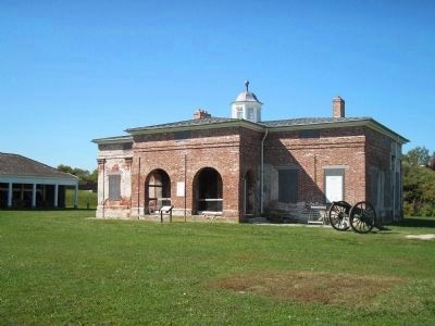
The brick structure built in the center of the parade ground as a Citadel was completed by 1796 in conjunction with Pierre Charles LíEnfantís plan for redesigning Fort Mifflin. Defense of the port of Philadelphia was particularly critical at the time, for the city served as the capital of the new nation. In military terms, a citadel meant a place of last retreat. In 1794 most seacoast fortifications along the Atlantic were required to include citadels built over ammunition magazines. No mention of such a magazine has been associated with Fort Mifflinís Citadel. Architectural investigation has shown, however, that forty-five gun portals were originally built at regular intervals in the two-foot thick walls. By standing on a platform, a soldier could have shot a musket through these openings. Additionally, a brick parapet [“breastwork of brick”] extending seven feet above the roof line hid a lookout platform [“gallery”] around the perimeter of the roof. A massive timber-frame truss system spanning the thirty-foot width of the building and two symmetrically placed chimneys provided flexibility of interior space. A central flagpole went through the roof and was used as a signal system to the city. The building had defensive characteristics, but Rivardiís comment implies they were not particularly successful.
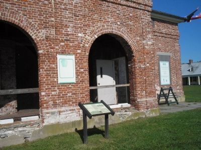
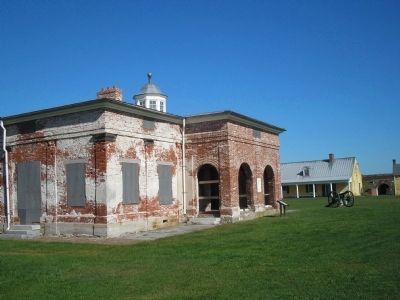
The rooms described in Rivardiís report and evidence from the building show it could also have been used as a residence, probably for an officer. The architectural symmetry and fine detailing of the initial 18th-century building – cut stone foundation, ornate brickwork, pilasters with wooden capitals, and a brick porch – imply the Citadel was created with a flare for design and style fit for the commander of a military post. In 1815 the building was referred to as the Commandantís House, and by then all the gun portals except those on the porch had been closed with brick.
Commandantís House
In 1802 Rivardi complained that the Citadel had structural problems, and such reports continued until the entire fort was rehabilitated in 1835. By that time the roof – with its gallery, flagpole, and weak chimneys – was sacrificed to change the building from a defensive Citadel to a residence for two commanding officers and their staff. Radical changes were made in the structure. The roof was raised to the top of the parapet, creating a second-floor living space where only a garret or attic had existed. The flagpole was left in place but was cut down to a stub that protruded from the top of an added, octagonal, windowed copula. The north chimney was moved from its symmetrical location and the south chimney was altered to achieve added fireplaces for more rooms. The foundation was reinforced with concrete and cement, and new joists and flooring were laid. All new interior walls, windows, doors, and woodwork were added, and end doors and windows were closed to make closets and walls. The porch was enclosed to create two vestibules. On the outside the entire building was stuccoed to hide all the changes.
The result was commanding officersí headquarters with rooms for two officers consisting of bedrooms and kitchens at the south end, a central hallway, and two offices at the north end. Separate vestibule entrances on the former porch led to each living area. The second
floor space served for servants or storage.
No record has ever been found showing that two officers shared this residence. After the Civil War, when the fort was rehabilitated, and innovative coal-burning stove was installed in one kitchen, and the building became a family residence. Plumbing was never installed in the building, but privies existed in the southwest corner of what became a backyard on the west side of the house. By the 20th century minimal electricity was added.
Erected by Fort Mifflin Historic Site.
Topics. This historical marker is listed in these topic lists: Forts and Castles • Notable Buildings. A significant historical date for this entry is January 16, 1796.
Location. 39° 52.511′ N, 75° 12.786′ W. Marker is in Philadelphia, Pennsylvania, in Philadelphia County. It is in Fort Mifflin. Marker can be reached from W Fort Mifflin Road, on the right when traveling east. Marker is along the walking tour of Fort Mifflin. Touch for map. Marker is at or near this postal address: 6400 Hog Island Rd, Philadelphia PA 19153, United States of America. Touch for directions.
Other nearby markers. At least 8 other markers are within walking distance of this marker. Torpedo Casemate (within shouting distance of this marker); Artillery Shed (within shouting distance of this marker); Blacksmith Shop (within shouting distance of this marker); Arsenal (within shouting
distance of this marker); West Sallyport (within shouting distance of this marker); Powder Magazine (within shouting distance of this marker); Soldiersí Barracks (within shouting distance of this marker); Quartermasterís Store (within shouting distance of this marker). Touch for a list and map of all markers in Philadelphia.
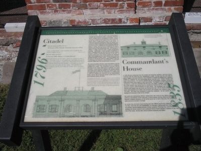
More about this marker. The bottom left of the marker features a picture of the Citadel with the caption “This drawing of the front of the 1796 Citadel is based on written and structural documentation and investigation. The seven-foot parapet wall that rises above the roof would have hidden the wooden walkway. Details on the railing around the flagpole are not known. The roof is depicted showing either slate shingles (left) or lead sheathing (right). The Flemish-band brick pattern found on the facades is completed in detail to the right where shutters are shown both opened and closed.”
A picture of the 1835 reconstructed Commandantís House appears at the upper right of the marker.
Related markers. Click here for a list of markers that are related to this marker. This series of markers follow the walking
tour of Fort Mifflin.
Also see . . .
1. The Fort that saved America. The Official Website of Fort Mifflin on the Delaware. (Submitted on October 18, 2008, by Bill Coughlin of Woodland Park, New Jersey.)
2. Fort Mifflin Groundplan. Layout of Fort Mifflin, the Fort that saved America. (Submitted on October 18, 2008, by Bill Coughlin of Woodland Park, New Jersey.)
Credits. This page was last revised on February 2, 2023. It was originally submitted on October 18, 2008, by Bill Coughlin of Woodland Park, New Jersey. This page has been viewed 1,369 times since then and 53 times this year. Photos: 1, 2. submitted on October 18, 2008, by Bill Coughlin of Woodland Park, New Jersey. 3. submitted on November 10, 2013, by Bill Coughlin of Woodland Park, New Jersey. 4, 5, 6. submitted on October 18, 2008, by Bill Coughlin of Woodland Park, New Jersey.
