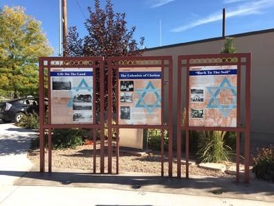
Gunnison in Sanpete County, Utah — The American Mountains (Southwest)
“Back to the Soil”
The pogroms (violent and usually deadly anti-Jewish riots) of the 19th Century saw the emigration of hundreds of thousands of Jews, mostly from Eastern Europe, who came to America with hopes of religious and economic freedom. The great majority of the Jews settled in the eastern cities. Others participated in an international movement that saw farm colonies planted in the United States, Canada, Argentina, Brazil and Israel. Forty agricultural colonies were organized in the United States at places such as Sicily Island, Louisiana, Crimea and Painted Woods in South Dakota; new Odessa, Oregon; and Cotopaxi in Colorado. Clarion, Utah was the largest in population and land areas and was in existence the longest of any settlement west of the Appalachian Mountains. Many communities suffered catastrophic natural disasters, while others succumbed to mismanagement, poor soils, and settler’s unfamiliarity with farm practices. All but a couple failed and were abandoned with a few years of their founding. Today, virtually all have disappeared.
In the early 20th Century, renewed pogroms and emigration from Eastern Europe added to the already overcrowded conditions in the cities of the eastern United States. Even president Theodore Roosevelt endorsed for all Americans a “Back to the Farm” movement and established the country Life Commission in 1908 to seek means to keep farmers on the land and to encourage new agricultural enterprises. These ideas would have been familiar to Jewish immigrants who had head similar schemes in their homelands even before their popularity in America.
Images:
Cotopaxi, Colorado. Circa 1882
A typical New York city tenement. circa 1900
Erected by Jewish American Society for Historic Preservation, Mormon Pioneer National Heritage.
Topics and series. This historical marker is listed in this topic list: Settlements & Settlers. In addition, it is included in the Former U.S. Presidents: #26 Theodore Roosevelt series list.
Location. 39° 9.285′ N, 111° 49.075′ W. Marker is in Gunnison, Utah, in Sanpete County. Marker is on East Center Street. Marker located in the City Square of Gunnison, Utah. Touch for map. Marker is in this post office area: Gunnison UT 84634, United States of America. Touch for directions.
Other nearby markers. At least 8 other markers are within 6 miles of this marker, measured as the crow flies. The Colonists of Clarion (here, next to this marker); Life on the Land (here, next to this marker); Casino / Star Theatre (about 300 feet away, measured in a direct line); Gunnison (approx. 0.3 miles away); First Public Buildings (approx. 2.3 miles away); Centerfield (approx. 2.3 miles away); Warm Creek-Fayette (approx. 5.2 miles away); ZCMI Co-op Building (approx. 5.3 miles away). Touch for a list and map of all markers in Gunnison.
Credits. This page was last revised on May 29, 2019. It was originally submitted on May 25, 2019, by Jerry Klinger of Boynton Beach, Florida. This page has been viewed 155 times since then and 10 times this year. Photos: 1, 2. submitted on May 25, 2019, by Jerry Klinger of Boynton Beach, Florida. • Bill Pfingsten was the editor who published this page.

