Finesville in Warren County, New Jersey — The American Northeast (Mid-Atlantic)
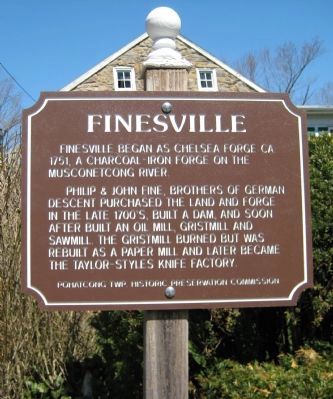
Finesville
Finesville began as Chelsea Forge, ca 1751, a charcoal - iron forge on the Musconetcong River.
Philip and John Fine, brothers of German descent purchased the forge in the late 1700's, built a dam, and soon after built an oil mill, gristmill and sawmill. The gristmill burned but was rebuilt as a paper mill and later became the Tayloe-Styles knife factory.
Erected by Pohatcong Twp. Historic Preservation Commission.
Topics. This historical marker is listed in this topic list: Settlements & Settlers. A significant historical year for this entry is 1751.
Location. 40° 36.397′ N, 75° 10.241′ W. Marker is in Finesville, New Jersey, in Warren County. Marker is at the intersection of Mt. Joy Road and Musconetcong Street, on the right when traveling north on Mt. Joy Road. Touch for map. Marker is in this post office area: Phillipsburg NJ 08865, United States of America. Touch for directions.
Other nearby markers. At least 8 other markers are within 2 miles of this marker, measured as the crow flies. Finesville Dam (about 400 feet away, measured in a direct line); Seigletown (approx. 0.6 miles away); Hunts Meadow (approx. 0.7 miles away); Volendam Windmill (approx. 0.8 miles away); Riegelsville Historic District (approx. 1.2 miles away); Hughesville (approx. 1.3 miles away); Riegelsville Roebling Bridge (approx. 1.4 miles away in Pennsylvania); Riegelsville (approx. 1.4 miles away in Pennsylvania). Touch for a list and map of all markers in Finesville.
Also see . . . Pohatcong History and Heritage Society. Society website homepage (Submitted on April 15, 2009.)
Credits. This page was last revised on November 9, 2021. It was originally submitted on April 12, 2009, by Alan Edelson of Union Twsp., New Jersey. This page has been viewed 2,287 times since then and 59 times this year. Photos: 1, 2, 3, 4. submitted on April 12, 2009, by Alan Edelson of Union Twsp., New Jersey. • Kevin W. was the editor who published this page.


