North End in Boston in Suffolk County, Massachusetts — The American Northeast (New England)
Paul Revere House
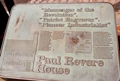
“Messenger of the Revolution”
“Patriot Engraver”
“Pioneer Industrialist”
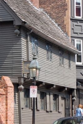
These are among history’s labels for Paul Revere, who occupied this small frame house on North Square from 1770 to 1800. Built about 1676 after one of the great fires of Boston, this is the oldest frame dwelling left in the city, and a rare example of 17th century domestic architecture. The house was witness not only to Revere’s increasing involvement in and commitment to the cause of Liberty, but also to three centuries of change in Boston’s North End, one of the city’s oldest and most historic neighborhoods. Evidence of these many years of diversity, activity, and continuity can be seen all around the Revere house here in North Square.
Erected by National Park Service.
Topics. This historical marker is listed in these topic lists: Notable Buildings • Patriots & Patriotism • War, US Revolutionary. A significant historical year for this entry is 1770.
Location. 42° 21.801′ N, 71° 3.224′ W. Marker is in Boston, Massachusetts, in Suffolk County. It is in North End. Marker is at the intersection of North Square and North Street, on the right when traveling north on North Square. Touch for map. Marker is in this post office area: Boston MA 02113, United States of America. Touch for directions.
Other nearby markers. At least 8 other markers are within walking distance of this marker. North Square (within shouting distance of this marker); Moses Pierce-Hichborn House (within shouting distance of this marker); North Square Houses, 1715 (within shouting distance of this marker); a different marker also named Paul Revere House (within shouting distance of this marker); a different marker also named The Paul Revere House (within shouting distance of this marker); Here Lived Paul Revere (within shouting distance of this marker); Sacco and Vanzetti Defense Committee (about 300 feet away, measured in a direct line); Garden Court Street (about 300 feet away). Touch for a list and map of all markers in Boston.
More about this marker. On the lower left is an engraving of the Paul Revere House. On the right is a map of the Freedom Trail, with the caption “In recognition of the national significance of seven of Boston’s oldest and most important historic sites, Congress has created the Boston National Historic Park. These sites, now part of our National Park System, are the Old South Meeting House, the Old State House, Faneuil Hall, Paul Revere House, Old North Church, the Bunker Hill Monument and part of the Charlestown Navy Yard, including U.S.S. Constitution.
This historic site is recognized under a cooperative agreement between the Paul Revere Memorial Association and the National Park Service, U.S. Department of the Interior. The Association owns the house and is responsible for the maintenance and operation while the National Park Service funds major rehabilitation and provides technical assistance."
Also see . . .
1. The Paul Revere House. Paul Revere Memorial Association. (Submitted on August 11, 2009, by Bernard Fisher of Richmond, Virginia.)
2. The Freedom Trail. The Freedom Trail Foundation. (Submitted on August 11, 2009, by Bernard Fisher of Richmond, Virginia.)
Credits. This page was last revised on January 30, 2023. It was originally submitted on August 11, 2009, by Bernard Fisher of Richmond, Virginia. This page has been viewed 1,180 times since then and 23 times this year. Photos: 1, 2, 3. submitted on August 11, 2009, by Bernard Fisher of Richmond, Virginia.


