Benicia in Solano County, California — The American West (Pacific Coastal)
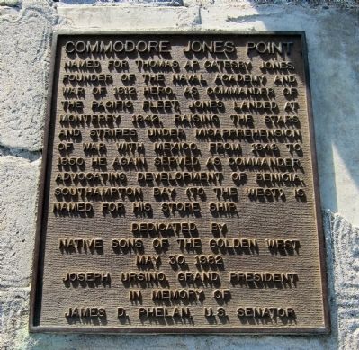
Commodore Jones Point
Native Sons of the Golden West
May 30, 1982
Joseph Ursino, Grand President
In Memory of
James D. Phelan, U.S. Senator
Erected 1982 by Native Sons of the Golden West.
Topics and series. This historical marker is listed in this topic list: Military. In addition, it is included in the Native Sons/Daughters of the Golden West series list. A significant historical month for this entry is May 2006.
Location. 38° 3.517′ N, 122° 10.504′ W. Marker is in Benicia, California, in Solano County. Marker can be reached from West Ninth Street near West I Street. Touch for map. Marker is in this post office area: Benicia CA 94510, United States of America. Touch for directions.
Other nearby markers. At least 8 other markers are within one mile of this marker, measured as the crow flies. Turner / Robertson Shipyard (approx. 0.3 miles away); McNear Warehouse (approx. one mile away); The Burlington Hotel (approx. one mile away); Site of the First Protestant Church in California (approx. one mile away); Fischer-Hanlon House (approx. 1.1 miles away); Founders of Benicia (approx. 1.1 miles away); Robert Semple (approx. 1.1 miles away); Old State Capitol (approx. 1.1 miles away). Touch for a list and map of all markers in Benicia.
More about this marker. The marker is mounted on a low stone-and-cement monument at the foot of the flagpole in Ninth Street Park.
Also see . . . The Pacific Theater of Naval Warfare in the Mexican-American War. The California State Military Museum's article on US Pacific naval operations against Mexico: "... Although war with Mexico did not break out until 12/13 May 1846, the United States Navy conducted operations against Mexico in the Pacific almost four years earlier. In September 1842, Commodore Thomas ap Catesby Jones was in command of the Pacific fleet, which at the time included the frigate United States and the sloop Cyane. Jones had learned in Lima, Peru that war with Mexico had broken out and that England had purchased California from Mexico in a secret treaty for $7 million. Jones invoked the Monroe Doctrine and set sail

Photographed By Andrew Ruppenstein, March 12, 2011
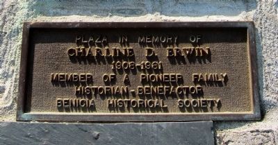
2. Commodore Jones Point - additional plaque below the main marker
Mounted on the monument below the main marker is a plaque that reads, "Plaza in memory of Charline D. Erwin, 1908-1891. Member of pioneer family. Historian-benefactor. Benicia Historical Society."

Photographed By Andrew Ruppenstein, March 12, 2011
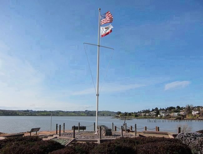
3. Commodore Jones Point Marker - view looking WNW
The monument and marker sit just to the right of the flagpole. In the background, Southampton Bay (into which the USS Southampton, under Jones' command, sailed in 1849) is visible to the left of the flagpole, while the location of the Turner Shipyard is visible just to the right of the flagpole.
Credits. This page was last revised on June 16, 2016. It was originally submitted on March 18, 2011, by Andrew Ruppenstein of Lamorinda, California. This page has been viewed 1,090 times since then and 25 times this year. Photos: 1, 2, 3. submitted on March 18, 2011, by Andrew Ruppenstein of Lamorinda, California. • Syd Whittle was the editor who published this page.
