Harrodsburg in Mercer County, Kentucky — The American South (East South Central)
The Lincoln Move to the Frontier
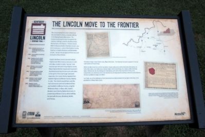
Captain Abraham Lincoln secured multiple Virginia land-office treasury warrants in 1780 and 1782, in order to claim, “secure,” and improve upon the land of any Virginia County. Many Virginia families moved west to present-day Kentucky during the late 1770s and 1780s. In the spirit of this much larger westward expansion, the Lincoln family migrated from eastern Virginia to Jefferson County, Virginia, in 1782. The Lincolns would have used the main land access point at Cumberland Gap and traveled to Jefferson County using the Wilderness Road. In May 1786, Captain Abraham was killed by Native Americans, in present-day Jefferson County, while working the land with his sons, Mordecai, Josiah, and Thomas.
(sidebar)
Kentucky Lincoln Heritage Trail
1809 Abraham Lincoln born at Sinking Spring farm, in present-day Larue County, Kentucky.
1816 Lincoln family moved from Kentucky.
1841 Abraham Lincoln visited his friend Joshua Speed at Farmington, the Speed family plantation, in Louisville, Kentucky.
1842 Abraham Lincoln married Mary Todd of Lexington, Kentucky.
1847 The Lincoln family visited Lexington, Kentucky, en route to Abrahamís only term in Congress.
1860 Abraham Lincoln elected President of the United States in November.
1865 Abraham Lincoln assassinated at Fordís Theatre in Washington, D.C.
www.kylincolntrail.com www.heritage.ky.gov www.kylincolntrail.org www.history.ky.gov www.transportation.ky.gov
A project of the Kentucky Abraham Lincoln Bicentennial Commission produced by the Kentucky Heritage Council in partnership with the Kentucky Historical Society and the Kentucky Transportation Cabinet
Erected by Kentucky Abraham Lincoln Bicentennial Commission.
Topics and series. This historical marker is listed in this topic list: Settlements & Settlers. In addition, it is included in the Former U.S. Presidents: #16 Abraham Lincoln series list. A significant historical month for this entry is January 1906.
Location. 37° 45.719′ N, 84° 50.758′ W. Marker is in Harrodsburg, Kentucky, in Mercer County. Marker can be reached from the intersection of South College Street (U.S. 127) and West Lexington Street, on the right when traveling south. Located in Old Fort Harrod State Park. Touch for map. Marker is at or near this postal address: 100 South College Street, Harrodsburg KY 40330, United States of America. Touch for directions.
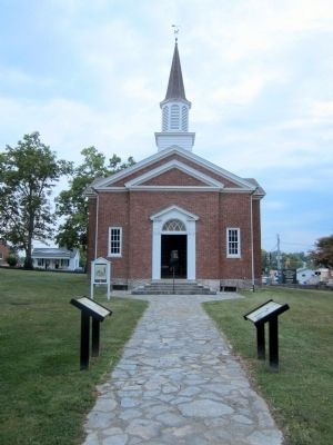
Other nearby markers. At least 8 other markers are within walking distance of this marker. Lincoln Marriage Temple (here, next to this marker); The Lincoln Marriage Cabin (a few steps from this marker); Fort Harrod (within shouting distance of this marker); The Mansion of the Pioneer Memorial State Park (within shouting distance of this marker); Osage Orange Tree (within shouting distance of this marker); Bowman Memorial Gate (about 300 feet away, measured in a direct line); St. Peter African Methodist Episcopal Church (about 300 feet away); White Hall (about 400 feet away). Touch for a list and map of all markers in Harrodsburg.
More about this marker. On the top center is a maps with the caption, "The above image is John Filsonís 1784, Map of Kentucke. The following inscription appears in the top right section of Filsonís map:
While this work shall live, let this inscription remain a Monument of the Gratitude of the Author, to Colls. Danl. Boon, Levi Todd, & Jas. Harrod, Capts. Christr Greenhoop, Ino. Cowan, & Wm. Kennedy. Esqrs. Of Kentucke: for the distinguished Assistance, with which they have honoríd him, in its Composition: & a testimony, that it has recieved [sic] the Approbation of those, whom he justly Esteems, the best qualified to Judge of its Merit.
Levi Todd, one of the defenders of Fort Harrod and an original resident of Lexington, Kentucky, is the grandfather of Mary Todd Lincoln."
On the bottom center is a map with the caption, "A survey map created by Luke Munsell of Frankfurt, Kentucky, in 1815, using a $6,000 loan appropriated by the Kentucky General Assembly on February 4, 1817." Courtesy of the Kentucky Historical Society
On the lower right is an image with the caption, "Virginia treasury warrants were purchased by individuals seeking to claim land on the new frontier in the late 18th century. These 1780 warrants are examples of several issued to “Abraham Linchorn,” grandfather of the future president of the United States, Abraham Lincoln." Courtesy of the Washington County Clerkís Office
Also see . . . Kentucky Lincoln Heritage Trail. (Submitted on August 21, 2011, by Bernard Fisher of Richmond, Virginia.)
Credits. This page was last revised on November 4, 2020. It was originally submitted on August 21, 2011, by Bernard Fisher of Richmond, Virginia. This page has been viewed 527 times since then and 17 times this year. Photos: 1, 2. submitted on August 21, 2011, by Bernard Fisher of Richmond, Virginia.

