Greenbrier West in Chesapeake, Virginia — The American South (Mid-Atlantic)
Liberty to Slaves
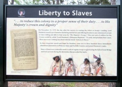
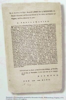
On November 15, 1775, the day after his success in routing the rebels at Kemp’s Landing, Lord Dunmore issued a proclamation declaring martial law and offering freedom to any indentured servant or slave willing and able to bear arms for “His Majesty’s Troops.” This new unit of soldiers for the Crown would be called “Lord Dunmore’s Ethiopian Regiment.” To unify and proclaim their cause, these men wore clothing inscribed with the words “Liberty to Slaves.”
In their desperate search and hope for freedom, some two to three hundred slaves immediately abandoned plantations in Princess Anne and Norfolk Counties and joined Dunmore’s ranks.
Many of them were ordered to assist a unit of regular troops in garrisoning the fort at Great Bridge and were present during the skirmishes that preceded the battle.
Erected 2012 by Great Bridge Battlefield & Waterways History Foundation.
Topics. This historical marker is listed in these topic lists: African Americans • War, US Revolutionary. A significant historical month for this entry is November 1839.
Location. 36° 43.317′ N, 76° 14.362′ W. Marker is in Chesapeake, Virginia. It is in Greenbrier West. Marker can be reached from the intersection of North Battlefield Boulevard (Business Virginia Route 168) and Watson Road, on the left when traveling south. Touch for map. Marker is in this post office area: Chesapeake VA 23320, United States of America. Touch for directions.
Other nearby markers. At least 8 other markers are within walking distance of this marker. Fort Murray (a few steps from this marker); Causeways (within shouting distance of this marker); Causeway Construction (within shouting distance of this marker); At Dawn On December 9, 1775 (within shouting distance of this marker); The Day is Our Own! (within shouting distance of this marker); Site of the Original Causeway (within shouting distance of this marker); First Fire (within shouting distance of this marker); Billy Flora (within shouting distance of this marker). Touch for a list and map of all markers in Chesapeake.
Also see . . .
1. Great Bridge Battlefield & Waterways History Foundation. (Submitted on April 29, 2012, by Bernard Fisher of Richmond, Virginia.)
2. Not ready for prime time Rev War history… here in the Valley?. Brief biographical sketch of Thomas Taylor Byrd, commanding officer of Dunmore's "Ethiopian Regiment". (Submitted on December 14, 2012, by Robert H. Moore, II of Winchester, Virginia.)
Credits. This page was last revised on February 1, 2023. It was originally submitted on April 29, 2012, by Bernard Fisher of Richmond, Virginia. This page has been viewed 1,016 times since then and 31 times this year. Photos: 1, 2, 3. submitted on April 29, 2012, by Bernard Fisher of Richmond, Virginia.


