Hurricane in Washington County, Utah — The American Mountains (Southwest)
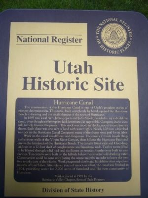
Hurricane Canal
Utah Historic Site
In 1893 two local men, James Jepsen and John Steele, decided to try to build the canal, even though earlier reports had determined it impossible. Company shares were sold to help finance the project. This stock was issued in blocks, not to exceed twenty shares. Each share was one acre of land with water rights. Nearly 100 men subscribed to stock in the Hurricane Canal Company; many of the shares were paid for in labor.
Work on the canal was difficult and dangerous. The canal's 7-1/2 mile length clings to the sheer walls of the Virgin River Canyon, then follows the Hurricane Fault and circles the farmlands of the Hurricane Bench. The canal is 8 feet wide and 4 feet deep, laid out on a 12-foot shelf of conglomerate and limestone rock. Twelve tunnels had to be blasted through solid rock and six flumes on wooden trestles were built to span ravines. Ten cisterns were built on the hillside below the canal to hold drinking water. Construction could be done only during the winter months in order to leave the men free to take care of their farms. Work progressed slowly and landslides often wiped out months of hard labor. After eleven years of tenacious effort, the canal was finished in 1904, providing water for 2,000 acres of farmland and the new community of Hurricane.
Erected 1992 by Hurricane Valley Chapter, Sons of Utah Pioneers.
Topics and series. This historical marker is listed in these topic lists: Bridges & Viaducts • Settlements & Settlers. In addition, it is included in the Sons of Utah Pioneers series list. A significant historical year for this entry is 1893.
Location. 37° 10.564′ N, 113° 17.315′ W. Marker is in Hurricane, Utah, in Washington County. Marker can be reached from West State Street. Marker is in Hurricane Valley Pioneer Heritage Park. Touch for map. Marker is at or near this postal address: 35 West State Street, Hurricane UT 84737, United States of America. Touch for directions.
Other nearby markers. At least 8 other markers are within walking distance of this marker. Pioneer Trails (here, next to this marker); Hurricane City (here, next to this marker); The Roads to Utah’s Dixie (a few steps from this marker); Survival in Utah’s Dixie (a few steps from this marker); Hurricane Pioneers (a few steps from this marker); Smith Mesa (a few steps from this marker); Pioneer Gratitude (a few steps from this marker); Historic Kolob Mountain (within shouting distance of this marker). Touch for a list and map of all markers in Hurricane.
Credits. This page was last revised on June 16, 2016. It was originally submitted on September 10, 2012, by Bill Kirchner of Tucson, Arizona. This page has been viewed 488 times since then and 19 times this year. Photos: 1, 2. submitted on September 10, 2012, by Bill Kirchner of Tucson, Arizona. • Syd Whittle was the editor who published this page.

