Middle Branch Park in Baltimore, Maryland — The American Northeast (Mid-Atlantic)
Reviving the Waterfront
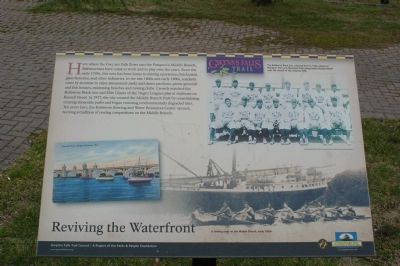
Here where the Gwynns Falls flows into the Patapsco's Middle Branch, Baltimoreans have come to work and to play over the years. Since the early 1700s this area his been home to mining operations, brickyards, glass factories, and other industries. In the late 1800s and early 1900s, residents came by streetcar to enjoy amusement parks and dance pavilions, picnic grounds and fish houses, swimming beaches and rowing clubs. Crowds watched the Baltimore Black Sox and Elite Giants of the Negro Leagues play at stadiums on Russell Street. In 1977, the city created the Middle Branch Park by consolidating existing shoreside parks and began restoring environmentally degraded sites. Ten years later, the Baltimore Rowing and Water Resources Center opened, reviving a tradition of rowing competitions on the Middle Branch.
[Caption:]
The Baltimore Black Sox, pictured here in 1929, played at Westport Park and Maryland Park along South Russell Street near the mouth of the Gwynns Falls.
Erected by Gwynns Falls Trail Council.
Topics and series. This historical marker is listed in these topic lists: African Americans • Industry & Commerce • Sports. In addition, it is included in the Maryland, Gwynns Falls Trail series list. A significant historical year for this entry is 1977.
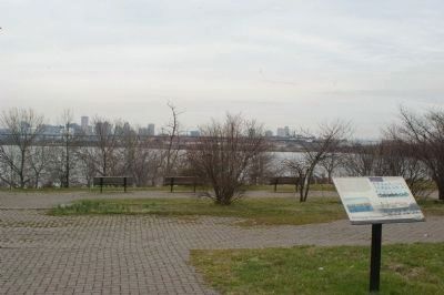
Location. Marker has been reported missing. It was located near 39° 15.283′ N, 76° 37.26′ W. Marker was in Baltimore, Maryland. It was in Middle Branch Park. Marker could be reached from Waterview Avenue. Marker is in Middle Branch Park. Touch for map. Marker was at or near this postal address: 3301 Waterview Ave, Baltimore MD 21230, United States of America. Touch for directions.
Other nearby markers. At least 8 other markers are within walking distance of this location. Senator Harry McGuirk (a few steps from this marker); Gwynns Falls Trail (within shouting distance of this marker); Maryland Vietnam Veterans Memorial (approx. ¼ mile away); John Smith Explores Patapsco (approx. 0.3 miles away); On Guard (approx. 0.3 miles away); Our Impact on Our Waters (approx. 0.4 miles away); Hippocrates' Platanus (Sycamore) (approx. 0.4 miles away); A River that Shaped a City (approx. half a mile away). Touch for a list and map of all markers in Baltimore.
Also see . . .
1. Image of the marker. (Submitted on March 18, 2008, by Christopher Busta-Peck of Shaker Heights, Ohio.)
2. Gwynns Falls Trail Council. (Submitted on March 18, 2008, by Christopher Busta-Peck of Shaker Heights, Ohio.)
Credits. This page was last revised on April 6, 2023. It was originally submitted on March 18, 2008, by Christopher Busta-Peck of Shaker Heights, Ohio. This page has been viewed 1,457 times since then and 9 times this year. Photos: 1, 2, 3. submitted on March 18, 2008, by Christopher Busta-Peck of Shaker Heights, Ohio.


