Adams in Robertson County, Tennessee — The American South (East South Central)
Stores of Port Royal
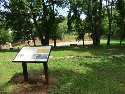
Port Royal State Historic Park
Where you are now standing was once the main street through Port Royal. Stores lined this street on either side for several hundred yards.
(Inscription under the photo on the bottom left)
This is Bertha Bourne on the front porch of her store around 1930. This store stood for many decades. It was located where the current highway bridge begins.
(Inscription under the photo in the bottom center)
These are letterheads from various stores located in Port Royal.
(Also)
An advertisement for B.F. Hamlett’s drug store.
(Inscription under the photo in the bottom right)
The Mallory Way Station served as a tavern and stagecoach inn from at least 1836 until the late 19th century. It later served as a grocery store and then a private residence in the 20th century. The Port Royal ferry was also operated by whomever owned this building. The foundation of this building is in front of you. Photo taken in mid 1970s.
Erected by Tennessee State Parks.
Topics. This historical marker is listed in this topic list: Settlements & Settlers. A significant historical year for this entry is 1930.
Location. 36° 33.233′ N, 87° 8.483′ W. Marker is in Adams, Tennessee, in Robertson County. Marker is on Port Royal Road (SR238) south of Old Clarksville Springfield Road, on the left when traveling south. Touch for map. Marker is in this post office area: Adams TN 37010, United States of America. Touch for directions.
Other nearby markers. At least 8 other markers are within 5 miles of this marker, measured as the crow flies. 1859 Masonic Lodge & General Store (within shouting distance of this marker); The Town of Port Royal (about 300 feet away, measured in a direct line); Port Royal (approx. 1.1 miles away); Renfroe's Station (approx. 3.4 miles away); Joseph Buckner Killebrew (1831-1906) (approx. 4.2 miles away); Red River Church (approx. 4.6 miles away); Bell Witch (approx. 4.9 miles away); Fort Redmond (approx. 4.9 miles away). Touch for a list and map of all markers in Adams.
Credits. This page was last revised on June 16, 2016. It was originally submitted on September 13, 2013, by Don Morfe of Baltimore, Maryland. This page has been viewed 515 times since then and 29 times this year. Photos: 1, 2. submitted on September 13, 2013, by Don Morfe of Baltimore, Maryland. • Al Wolf was the editor who published this page.

