Annandale in Fairfax County, Virginia — The American South (Mid-Atlantic)
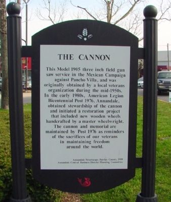
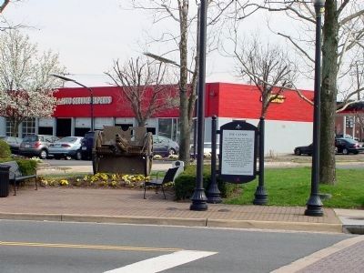
The Cannon
Erected 1999 by Annandale Streetscape, Fairfax County, and the Annandale Central Business District Planning Committee.
Topics. This historical marker is listed in this topic list: Military. A significant historical year for this entry is 1905.
Location. 38° 49.866′ N, 77° 11.664′ W. Marker is in Annandale, Virginia, in Fairfax County. Marker is at the intersection of Backlick Road (County Route 617) and Columbia Pike (Virginia Route 244), in the median on Backlick Road. Touch for map. Marker is in this post office area: Annandale VA 22003, United States of America. Touch for directions.
Other nearby markers. At least 8 other markers are within 2 miles of this marker, measured as the crow flies. Little River Turnpike (about 700 feet away, measured in a direct line); Action At Annandale (approx. half a mile away); Mosby Attacks Annandale (approx. one mile away); Mason's Hill (approx. 1.2 miles away); Price’s Ordinary (approx. 1.4 miles away); a different marker also named Mason’s Hill (approx. 1.7 miles away); Historic Green Spring (approx. 1.9 miles away); Mount Pleasant Baptist Church (approx. 2 miles away). Touch for a list and map of all markers in Annandale.
Regarding The Cannon. The Pancho Villa Expedition, also known as the Mexican Expedition and the Punitive Expedition, occurred from March 1916 to February 1917. U.S. Forces under General John J. Pershing crossed into Mexico after Pancho Villa’s forces after his incursions into the U.S. and his attack of Columbus, New Mexico, and the U.S. Army regiment there.
Also see . . . Pancho Villa, A Punitive Expedition. “After a raid on U.S. soil by the men of Mexican revolutionary Pancho Villa, President Woodrow Wilson responded by ordering a punitive expedition into Mexico to capture Villa dead or alive.” (Submitted on April 5, 2008.)
Credits. This page was last revised on June 16, 2016. It was originally submitted on April 5, 2008, by J. J. Prats of Powell, Ohio. This page has been viewed 4,260 times since then and 102 times this year. Photos: 1, 2, 3. submitted on April 5, 2008, by J. J. Prats of Powell, Ohio.


