Green Brook in Somerset County, New Jersey — The American Northeast (Mid-Atlantic)
Washington Rock
Washington Rock State Park
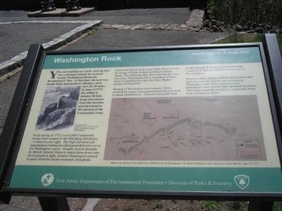
In the spring of 1777, over 8,000 Continental troops were camped in the Watchung Mountains – 3 miles to your right. The high elevation and mountainous terrain provided good defensive cover for Washington’s army. Despite several attempts by British General Howe to entice them down onto level ground to fight, General Washington refused to move from his secure mountain stronghold.
Frustrated that his tactics had failed, Howe moved his troops to Perth Amboy and then to Staten Island. The following day, observing that the coast was clear, Washington sent a contingent of men down to Quibbletown (now the New Market section of Plainfield).
Hearing of Washington’s movements, Howe recalled his troops and organized and led a division to attack Quibbletown. General Cornwallis took another British division to circle behind the Continentals and cut off their retreat route to the mountains.
Watching these maneuvers from this lookout and realizing what the British were attempting, Washington ordered his troops to return immediately and refortify their mountain positions. This action assuredly saved the Continental Army from a disastrous defeat.
Erected by Washington Rock State Park - State of New Jersey.
Topics and series. This historical marker is listed in these topic lists: Military • Notable Places • War, US Revolutionary. In addition, it is included in the Former U.S. Presidents: #01 George Washington series list. A significant historical month for this entry is June 1777.
Location. 40° 36.765′ N, 74° 28.342′ W. Marker is in Green Brook, New Jersey, in Somerset County. Marker is on Washington Avenue, on the right when traveling north. Marker is in Washington Rock State Park. Touch for map. Marker is in this post office area: Dunellen NJ 08812, United States of America. Touch for directions.
Other nearby markers. At least 8 other markers are within 3 miles of this marker, measured as the crow flies. A different marker also named Washington Rock (here, next to this marker); a different marker also named Washington Rock (within shouting distance of this marker); Site of the Blue Hills Fort and Camp (approx. 1.6 miles away); World War II 50th Anniversary Commemorative Memorial (approx. 2.1 miles away); Drake House (approx. 2.1 miles away); Drake House Flag Pole (approx. 2.1 miles away); Revolutionary War Skirmishes in the Area (approx. 2.6 miles away); Mt. Bethel Meeting House (approx. 2.8 miles away). Touch for a list and map of all markers in Green Brook.
More about this marker. The left of the marker features a picture of “Washington Rock Illustrated by Jules Tavernier, 1872. Source: The Library Company of Philadelphia.”
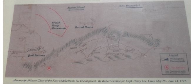
The lower right of the marker contains a “Manuscript Chart of the First Middlebrook, NJ Encampment. By Robert Erskine for Capt. Henry Lee, Circa May 28 – June 14, 1777.”
Additional commentary.
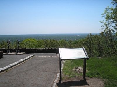
1. Photo showing George Washington's encampment and surrounding towns
Thank you very much for posting this photo. One of my ancestors was born on land "under Washington Rock", aka Bound Brook, and until I saw this photo, I could not see where his birthplace lay in relation to Washington Rock.
Ancestor- John H. Marsalis was born 1745 in Bound Brook, son of Harman Marselis and Hannah Hutchins.
During the American Revolution, the land that was to become Dunellen, New Jersey was known as the "Militia Post in
the Blue Hills 1776" as written by C. C. Vermeule, whose plantation was utilized as a fort.
The land known as Dunellen now, was occupied by Peter Marselis, Zachariah Pound and David Coriell.
Elisha, David Coriell and John and Peter Marselis were members of the Middlesex Militia.
— Submitted September 20, 2012, by Shannon Gorman of Columbia, Mississippi.
Credits. This page was last revised on June 16, 2016. It was originally submitted on May 17, 2008, by Bill Coughlin of Woodland Park, New Jersey. This page has been viewed 1,705 times since then and 42 times this year. Photos: 1, 2, 3, 4, 5. submitted on May 17, 2008, by Bill Coughlin of Woodland Park, New Jersey. • Kevin W. was the editor who published this page.
