West Rupert in Bennington County, Vermont — The American Northeast (New England)
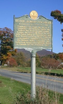
Lt. Col. Robert Cochran
Revolutionary Hero Settled Here, 1769
Erected 1958 by Vermont Historic Sites Commission.
Topics. This historical marker is listed in these topic lists: Patriots & Patriotism • Settlements & Settlers • War, US Revolutionary.
Location. 43° 13.655′ N, 73° 15.522′ W. Marker is in Rupert, Vermont, in Bennington County. It is in West Rupert. Marker is on Vermont Route 153. Located at the Vermont/New York border. Touch for map. Marker is in this post office area: Rupert VT 05768, United States of America. Touch for directions.
Other nearby markers. At least 8 other markers are within 6 miles of this marker, measured as the crow flies. West Rupert Veterans Memorial (approx. 1.2 miles away); Town of Rupert World War II Memorial (approx. 2.7 miles away); Town of Rupert Great War Memorial (approx. 2.7 miles away); Hebron School District No. 16 (approx. 2.8 miles away in New York); Lest We Forget (approx. 5 miles away in New York); General John Williams (approx. 5 miles away in New York); 1852 Rail Yard (approx. 5.1 miles away in New York); The White Creek Fort (approx. 5.1 miles away in New York). Touch for a list and map of all markers in Rupert.
Credits. This page was last revised on February 16, 2023. It was originally submitted on October 13, 2014, by John Arsenault of Middletown Springs, Vermont. This page has been viewed 809 times since then and 57 times this year. Photo 1. submitted on October 13, 2014, by John Arsenault of Middletown Springs, Vermont. • Bill Pfingsten was the editor who published this page.
