A Timeless Place
Upper Spring
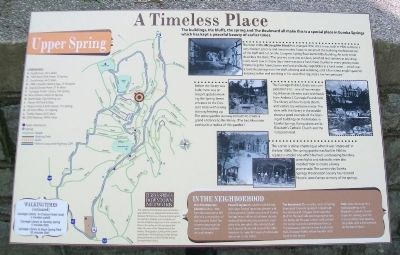
The buildings, the bluffs, the spring and The Boulevard all make this a special place in Eureka Springs which has kept a peaceful beauty of earlier times.
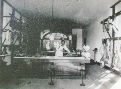
The front of the McLaughlin Block has changed little since it was built in 1900 to house a very modern grocery and meat market. Stone to construct the building was blasted out of the bluff and cut on-site. Congress Spring flows behind the building. An early writer describes the store: "The grocery store was as clean, polished and sanitary as any drug store I ever saw. In those days there was not a fresh meat counter in every grocery store. Homer kept his hams, bacon and lard and bulky vegetables in a back room... which was a cavelike passage into the bluff, winding and widening until it furnished ample space for keeping butter and anything in his stock that required a low temperature."
Before the library was built, there was an elegant gazebo marking the Spring Street entrance to the Crescent Hotel with a long stairway leading up. The stone gazebo stairway remains to create a grand entrance to the library. (The East Mountain Lookout is a replica of this gazebo.)
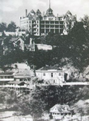
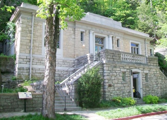
The Carnegie Public Library was completed in 1912 -- one of two remaining Arkansas libraries built with funds from Andrew J. Carnegie Foundation. The library still has its early charm and visitors
are welcome inside. This view with the library in the middle shows a good example of the layering of buildings on the hillsides in Eureka Springs. Rising above are St. Elizabeth's Catholic Church and the Crescent Hotel.This corner is still as charming as when it was "improved" in the late 1880s. The spring gazebo was built in 1885 to replace a simpler one which burned. Landscaping, benches, street lights and sidewalks were also installed then to create a lovely promenade. The current-day Eureka Spring Preservation Society has restored historic street lamps to many of the springs.
In The Neighborhood
First Presbyterian Church: Built in 1886 from donated stone left after the construction of the Crescent Hotel. The current congregation recently restored the unusual steeple.
Powell Clayton: He and his family lived next door. Former governor, senator and Union general, Clayton was one of Eureka Springs' most influential citizens. He was leader of the Eureka Improvement Company who brought in the railroad, built the Crescent Hotel and most of the infrastructure to make this town a fashionable spa resort in the 1890s.
The Boulevard: This was the name of Spring Street past Crescent Spring. It is lined with fine homes and cottages which abut the bluff on the west side and drop several stories below on the east. A short walk around the corner is
a nod to prehistoric times, a Styracosaurus albertensis from local attraction, Dinosaur World, whose founder once lived in this house.Trail: Note the steps for a walking path up to St. Elizabeth's Catholic Church (open for viewing) and the Crescent Hotel (also open to the public with a fine overlook on the fourth floor.)
Landmarks [Map and Key]
This material is based upon work assisted by a grant from the U.S. Department of the Interior, National Park Service, a Preserve America grant. Any opinions, findings, and conclusions or recommendations expressed in this material are those of the author and do not necessarily reflect the views of the Department of the Interior. Photographs courtesy of the Cornerstone Bank of Eureka Springs, Eureka Springs Historical Museum and the Eureka Springs Carnegie Public Library.
Erected by Eureka Springs Downtown Network.
Topics and series. This historical marker is listed in these topic lists: Churches & Religion • Industry & Commerce • Settlements & Settlers. In addition, it is included in the Carnegie Libraries series list. A significant historical year for this entry is 1900.
Location. 36° 24.447′ N, 93° 44.197′ W. Marker is in Eureka Springs, Arkansas, in Carroll County. Marker is on Spring Street
Other nearby markers. At least 8 other markers are within walking distance of this marker. Carnegie Library (here, next to this marker); Crescent Spring and Trail (within shouting distance of this marker); Clayton-Becker House (about 300 feet away, measured in a direct line); The Crescent Hotel & Spa (about 400 feet away); Avarana (about 700 feet away); Harding Spring (about 700 feet away); The Lay of the Land (about 700 feet away); Eastview Cottage (approx. 0.2 miles away). Touch for a list and map of all markers in Eureka Springs.
Also see . . . Eureka Springs History. City website homepage (Submitted on January 5, 2015, by William Fischer, Jr. of Scranton, Pennsylvania.)
Credits. This page was last revised on June 18, 2022. It was originally submitted on January 5, 2015, by William Fischer, Jr. of Scranton, Pennsylvania. This page has been viewed 547 times since then and 28 times this year. Photos: 1, 2, 3, 4. submitted on January 5, 2015, by William Fischer, Jr. of Scranton, Pennsylvania.


