Oak Ridge in Roane County, Tennessee — The American South (East South Central)
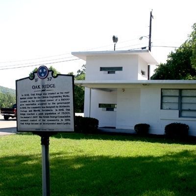
Oak Ridge
Erected by Tennessee Historical Commission. (Marker Number 1F 37.)
Topics and series. This historical marker is listed in these topic lists: Industry & Commerce • Settlements & Settlers. In addition, it is included in the Tennessee Historical Commission series list. A significant historical year for this entry is 1943.
Location. Marker is missing. It was located near 35° 58.825′ N, 84° 20.046′ W. Marker was in Oak Ridge, Tennessee, in Roane County. Marker was on Oak Ridge Turnpike (Tennessee Route 95) just west of Westover Drive. Touch for map. Marker was in this post office area: Oak Ridge TN 37830, United States of America. Touch for directions.
Other nearby markers. At least 8 other markers are within 5 miles of this location, measured as the crow flies. Oak Ridge Turnpike Checking Station (within shouting distance of this marker); Erected in Memory of New Bethel Baptist Church (approx. 3.6 miles away); The Wheat Community (approx. 3.7 miles away); Poplar Creek Seminary (approx. 3.8 miles away); The Robertsville Community (approx. 4 miles away); Midtown Community Center (approx. 4.4 miles away); L&N Cowcreel Branch (approx. 4˝ miles away); The Emery Road (approx. 4˝ miles away). Touch for a list and map of all markers in Oak Ridge.
Additional commentary.
1. Marker is missing 09 10 2015
A visit to site today finds no marker at the site of the old guard tower on Hiway 95 Roane Co., Oak Ridge.
Will update if more is learned
— Submitted September 10, 2015, by Donald Raby of Knoxville, Tennessee.
Credits. This page was last revised on January 9, 2020. It was originally submitted on June 30, 2010, by Donald Raby of Knoxville, Tennessee. This page has been viewed 1,500 times since then and 11 times this year. Last updated on April 9, 2015, by J. Makali Bruton of Accra, Ghana. Photos: 1. submitted on July 3, 2010, by Donald Raby of Knoxville, Tennessee. 2. submitted on June 29, 2010, by Donald Raby of Knoxville, Tennessee. • Bill Pfingsten was the editor who published this page.

